You are here: Home > Network List > IU - Global Seismograph Network (GSN - IRIS/USGS) Stations List
> Station RSSD Black Hills, South Dakota, USA > Earthquake Result Viewer
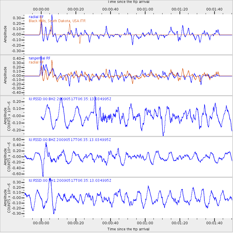
RSSD Black Hills, South Dakota, USA - Earthquake Result Viewer
*The percent match for this event was below the threshold and hence no stack was calculated.
| Earthquake location: |
Tonga Islands |
| Earthquake latitude/longitude: |
-16.8/-173.5 |
| Earthquake time(UTC): |
2009/05/17 (137) 06:23:03 GMT |
| Earthquake Depth: |
67 km |
| Earthquake Magnitude: |
5.5 MB, 5.6 MW, 5.6 MW |
| Earthquake Catalog/Contributor: |
WHDF/NEIC |
|
| Network: |
IU Global Seismograph Network (GSN - IRIS/USGS) |
| Station: |
RSSD Black Hills, South Dakota, USA |
| Lat/Lon: |
44.12 N/104.04 W |
| Elevation: |
2060 m |
|
| Distance: |
87.6 deg |
| Az: |
42.455 deg |
| Baz: |
243.847 deg |
| Ray Param: |
$rayparam |
*The percent match for this event was below the threshold and hence was not used in the summary stack. |
|
| Radial Match: |
67.92134 % |
| Radial Bump: |
400 |
| Transverse Match: |
52.157238 % |
| Transverse Bump: |
400 |
| SOD ConfigId: |
590571 |
| Insert Time: |
2013-09-27 14:02:18.635 +0000 |
| GWidth: |
2.5 |
| Max Bumps: |
400 |
| Tol: |
0.001 |
|
Signal To Noise
| Channel | StoN | STA | LTA |
| IU:RSSD:00:BHZ:20090517T06:35:13.034995Z | 3.0041516 | 2.9794967E-7 | 9.91793E-8 |
| IU:RSSD:00:BH1:20090517T06:35:13.034995Z | 2.0926921 | 1.4467655E-7 | 6.913418E-8 |
| IU:RSSD:00:BH2:20090517T06:35:13.034995Z | 1.0602942 | 1.184561E-7 | 1.1172004E-7 |
| Arrivals |
| Ps | |
| PpPs | |
| PsPs/PpSs | |


