You are here: Home > Network List > IU - Global Seismograph Network (GSN - IRIS/USGS) Stations List
> Station RSSD Black Hills, South Dakota, USA > Earthquake Result Viewer
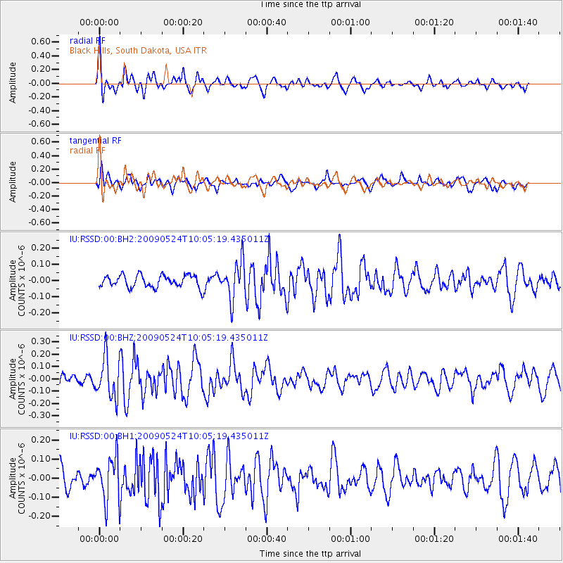
RSSD Black Hills, South Dakota, USA - Earthquake Result Viewer
*The percent match for this event was below the threshold and hence no stack was calculated.
| Earthquake location: |
Central East Pacific Rise |
| Earthquake latitude/longitude: |
-4.1/-104.0 |
| Earthquake time(UTC): |
2009/05/24 (144) 09:57:11 GMT |
| Earthquake Depth: |
6.0 km |
| Earthquake Magnitude: |
5.6 MW, 5.5 MW |
| Earthquake Catalog/Contributor: |
NEIC PDE/NEIC PDE-M |
|
| Network: |
IU Global Seismograph Network (GSN - IRIS/USGS) |
| Station: |
RSSD Black Hills, South Dakota, USA |
| Lat/Lon: |
44.12 N/104.04 W |
| Elevation: |
2060 m |
|
| Distance: |
48.0 deg |
| Az: |
359.935 deg |
| Baz: |
179.91 deg |
| Ray Param: |
$rayparam |
*The percent match for this event was below the threshold and hence was not used in the summary stack. |
|
| Radial Match: |
59.95618 % |
| Radial Bump: |
400 |
| Transverse Match: |
64.98933 % |
| Transverse Bump: |
400 |
| SOD ConfigId: |
590571 |
| Insert Time: |
2013-09-27 14:17:22.383 +0000 |
| GWidth: |
2.5 |
| Max Bumps: |
400 |
| Tol: |
0.001 |
|
Signal To Noise
| Channel | StoN | STA | LTA |
| IU:RSSD:00:BHZ:20090524T10:05:19.435011Z | 2.8758142 | 1.690452E-7 | 5.8781684E-8 |
| IU:RSSD:00:BH1:20090524T10:05:19.435011Z | 2.3565786 | 1.1771915E-7 | 4.9953417E-8 |
| IU:RSSD:00:BH2:20090524T10:05:19.435011Z | 3.1076152 | 1.1644662E-7 | 3.7471377E-8 |
| Arrivals |
| Ps | |
| PpPs | |
| PsPs/PpSs | |


