You are here: Home > Network List > II - Global Seismograph Network (GSN - IRIS/IDA) Stations List
> Station AAK Ala Archa, Kyrgyzstan > Earthquake Result Viewer
AAK Ala Archa, Kyrgyzstan - Earthquake Result Viewer
| Earthquake location: |
Kuril Islands |
| Earthquake latitude/longitude: |
44.3/148.4 |
| Earthquake time(UTC): |
2001/05/25 (145) 00:40:50 GMT |
| Earthquake Depth: |
33 km |
| Earthquake Magnitude: |
6.1 MB, 6.7 MS, 6.7 MW, 6.6 MW |
| Earthquake Catalog/Contributor: |
WHDF/NEIC |
|
| Network: |
II Global Seismograph Network (GSN - IRIS/IDA) |
| Station: |
AAK Ala Archa, Kyrgyzstan |
| Lat/Lon: |
42.64 N/74.49 E |
| Elevation: |
1645 m |
|
| Distance: |
51.9 deg |
| Az: |
295.787 deg |
| Baz: |
61.241 deg |
| Ray Param: |
0.0670198 |
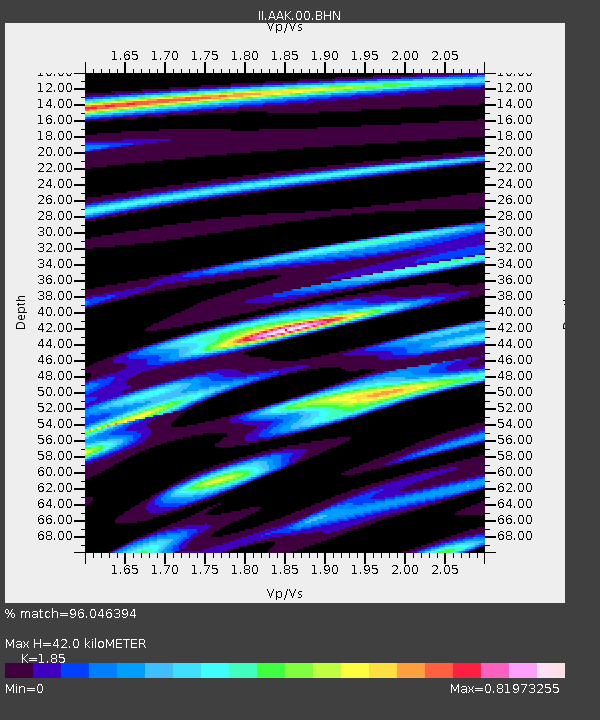
| Estimated Moho Depth: |
42.0 km |
| Estimated Crust Vp/Vs: |
1.85 |
| Assumed Crust Vp: |
6.306 km/s |
| Estimated Crust Vs: |
3.409 km/s |
| Estimated Crust Poisson's Ratio: |
0.29 |
|
| Radial Match: |
96.046394 % |
| Radial Bump: |
400 |
| Transverse Match: |
93.15642 % |
| Transverse Bump: |
400 |
| SOD ConfigId: |
4714 |
| Insert Time: |
2010-03-01 15:23:43.928 +0000 |
| GWidth: |
2.5 |
| Max Bumps: |
400 |
| Tol: |
0.001 |
|

Signal To Noise
| Channel | StoN | STA | LTA |
| II:AAK:00:BHN:20010525T00:49:25.626001Z | 18.100672 | 4.1439748E-7 | 2.2894037E-8 |
| II:AAK:00:BHE:20010525T00:49:25.626001Z | 11.428785 | 4.0097913E-7 | 3.508502E-8 |
| II:AAK:00:BHZ:20010525T00:49:25.626001Z | 17.889568 | 1.0555119E-6 | 5.9001536E-8 |
| Arrivals |
| Ps | 6.0 SECOND |
| PpPs | 18 SECOND |
| PsPs/PpSs | 24 SECOND |


