You are here: Home > Network List > IU - Global Seismograph Network (GSN - IRIS/USGS) Stations List
> Station RSSD Black Hills, South Dakota, USA > Earthquake Result Viewer
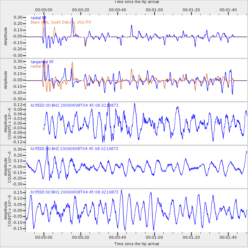
RSSD Black Hills, South Dakota, USA - Earthquake Result Viewer
*The percent match for this event was below the threshold and hence no stack was calculated.
| Earthquake location: |
South Of Fiji Islands |
| Earthquake latitude/longitude: |
-22.2/-179.6 |
| Earthquake time(UTC): |
2009/06/08 (159) 04:33:19 GMT |
| Earthquake Depth: |
612 km |
| Earthquake Magnitude: |
5.5 MW, 5.2 MB |
| Earthquake Catalog/Contributor: |
WHDF/NEIC |
|
| Network: |
IU Global Seismograph Network (GSN - IRIS/USGS) |
| Station: |
RSSD Black Hills, South Dakota, USA |
| Lat/Lon: |
44.12 N/104.04 W |
| Elevation: |
2060 m |
|
| Distance: |
95.4 deg |
| Az: |
44.481 deg |
| Baz: |
244.341 deg |
| Ray Param: |
$rayparam |
*The percent match for this event was below the threshold and hence was not used in the summary stack. |
|
| Radial Match: |
67.8966 % |
| Radial Bump: |
400 |
| Transverse Match: |
47.927597 % |
| Transverse Bump: |
400 |
| SOD ConfigId: |
590571 |
| Insert Time: |
2013-09-27 14:55:14.252 +0000 |
| GWidth: |
2.5 |
| Max Bumps: |
400 |
| Tol: |
0.001 |
|
Signal To Noise
| Channel | StoN | STA | LTA |
| IU:RSSD:00:BHZ:20090608T04:45:08.021987Z | 2.4827337 | 1.6304352E-7 | 6.567097E-8 |
| IU:RSSD:00:BH1:20090608T04:45:08.021987Z | 0.7451823 | 4.2161034E-8 | 5.657815E-8 |
| IU:RSSD:00:BH2:20090608T04:45:08.021987Z | 1.5495286 | 6.4672285E-8 | 4.1736747E-8 |
| Arrivals |
| Ps | |
| PpPs | |
| PsPs/PpSs | |


