You are here: Home > Network List > IU - Global Seismograph Network (GSN - IRIS/USGS) Stations List
> Station RSSD Black Hills, South Dakota, USA > Earthquake Result Viewer
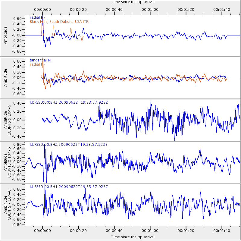
RSSD Black Hills, South Dakota, USA - Earthquake Result Viewer
*The percent match for this event was below the threshold and hence no stack was calculated.
| Earthquake location: |
Southern Alaska |
| Earthquake latitude/longitude: |
61.9/-150.7 |
| Earthquake time(UTC): |
2009/06/22 (173) 19:28:05 GMT |
| Earthquake Depth: |
65 km |
| Earthquake Magnitude: |
5.5 MW, 5.5 MW, 5.6 MB |
| Earthquake Catalog/Contributor: |
NEIC PDE/NEIC PDE-M |
|
| Network: |
IU Global Seismograph Network (GSN - IRIS/USGS) |
| Station: |
RSSD Black Hills, South Dakota, USA |
| Lat/Lon: |
44.12 N/104.04 W |
| Elevation: |
2060 m |
|
| Distance: |
32.3 deg |
| Az: |
101.588 deg |
| Baz: |
319.969 deg |
| Ray Param: |
$rayparam |
*The percent match for this event was below the threshold and hence was not used in the summary stack. |
|
| Radial Match: |
61.71951 % |
| Radial Bump: |
400 |
| Transverse Match: |
63.80548 % |
| Transverse Bump: |
400 |
| SOD ConfigId: |
590571 |
| Insert Time: |
2013-09-27 15:21:55.478 +0000 |
| GWidth: |
2.5 |
| Max Bumps: |
400 |
| Tol: |
0.001 |
|
Signal To Noise
| Channel | StoN | STA | LTA |
| IU:RSSD:00:BHZ:20090622T19:33:57.923Z | 3.4238122 | 3.9422014E-7 | 1.151407E-7 |
| IU:RSSD:00:BH1:20090622T19:33:57.923Z | 3.358394 | 2.9785159E-7 | 8.86887E-8 |
| IU:RSSD:00:BH2:20090622T19:33:57.923Z | 1.4324075 | 1.3916603E-7 | 9.715534E-8 |
| Arrivals |
| Ps | |
| PpPs | |
| PsPs/PpSs | |


