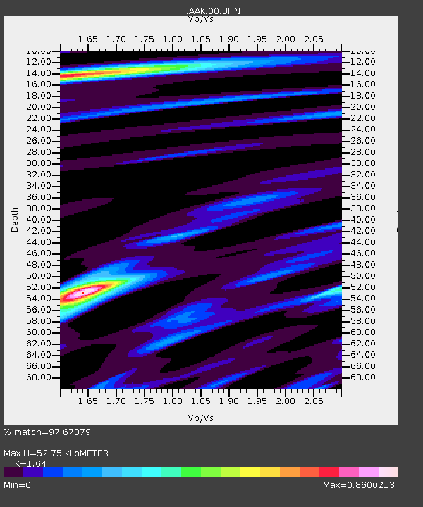
AAK Ala Archa, Kyrgyzstan - Earthquake Result Viewer

Earthquake location: Near East Coast Of Kamchatka
Earthquake latitude/longitude: 54.8/162.0
Earthquake time(UTC): 1997/12/05 (339) 11:26:54 GMT
Earthquake Depth: 33 km
Earthquake Magnitude: 6.3 MB, 7.6 MS, 7.9 UNKNOWN, 7.3 ME
Earthquake Catalog/Contributor: WHDF/NEIC
Network: II Global Seismograph Network (GSN - IRIS/IDA)
Station: AAK Ala Archa, Kyrgyzstan
Lat/Lon: 42.64 N/74.49 E
Elevation: 1645 m
Distance: 55.3 deg
Az: 296.313 deg
Baz: 44.642 deg
Ray Param: 0.0648044
Estimated Moho Depth: 52.75 km
Estimated Crust Vp/Vs: 1.64
Assumed Crust Vp: 6.306 km/s
Estimated Crust Vs: 3.845 km/s
Estimated Crust Poisson's Ratio: 0.20
Radial Match: 97.67379 %
Radial Bump: 400
Transverse Match: 94.31683 %
Transverse Bump: 400
SOD ConfigId: 4480
Insert Time: 2010-03-01 15:24:46.364 +0000
GWidth: 2.5
Max Bumps: 400
Tol: 0.001

Signal To Noise

ChannelStoNSTALTA
II:AAK:00:BHN:19971205T11:35:54.448022Z5.6536793.0928963E-65.470591E-7
II:AAK:00:BHE:19971205T11:35:54.448022Z4.44651561.2341342E-62.7755084E-7
II:AAK:00:BHZ:19971205T11:35:54.448022Z3.77336967.6022303E-72.014706E-7
Arrivals
Ps5.7 SECOND
PpPs21 SECOND
PsPs/PpSs27 SECOND