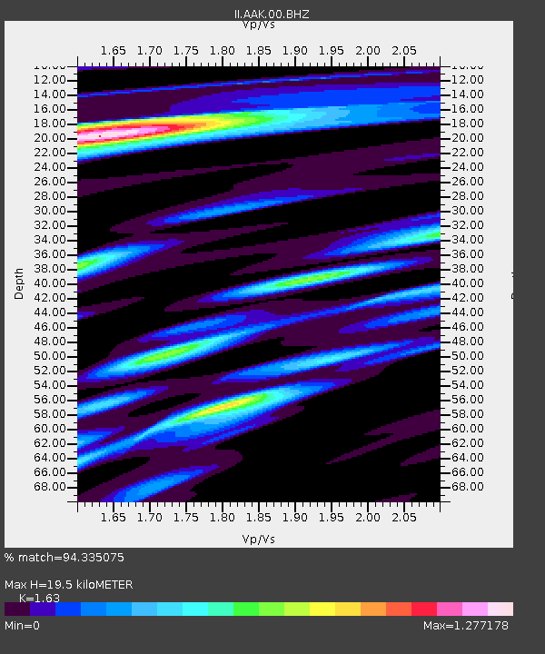
AAK Ala Archa, Kyrgyzstan - Earthquake Result Viewer
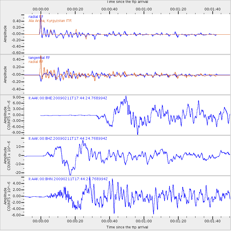
Earthquake location: Talaud Islands, Indonesia
Earthquake latitude/longitude: 3.9/126.4
Earthquake time(UTC): 2009/02/11 (042) 17:34:50 GMT
Earthquake Depth: 22 km
Earthquake Magnitude: 6.6 MB, 7.2 MS, 7.2 MW, 7.1 MW
Earthquake Catalog/Contributor: WHDF/NEIC
Network: II Global Seismograph Network (GSN - IRIS/IDA)
Station: AAK Ala Archa, Kyrgyzstan
Lat/Lon: 42.64 N/74.49 E
Elevation: 1645 m
Distance: 60.0 deg
Az: 317.903 deg
Baz: 114.981 deg
Ray Param: 0.06177766
Estimated Moho Depth: 19.5 km
Estimated Crust Vp/Vs: 1.63
Assumed Crust Vp: 6.306 km/s
Estimated Crust Vs: 3.869 km/s
Estimated Crust Poisson's Ratio: 0.20
Radial Match: 94.335075 %
Radial Bump: 400
Transverse Match: 89.376564 %
Transverse Bump: 400
SOD ConfigId: 2658
Insert Time: 2010-03-01 15:24:47.929 +0000
GWidth: 2.5
Max Bumps: 400
Tol: 0.001

Signal To Noise

ChannelStoNSTALTA
II:AAK:00:BHZ:20090211T17:44:24.768994Z28.099121.814719E-66.458277E-8
II:AAK:00:BHN:20090211T17:44:24.768994Z2.0178351.2212662E-76.0523604E-8
II:AAK:00:BHE:20090211T17:44:24.768994Z9.2604047.446316E-78.0410274E-8
Arrivals
Ps2.0 SECOND
PpPs7.7 SECOND
PsPs/PpSs9.8 SECOND