You are here: Home > Network List > IU - Global Seismograph Network (GSN - IRIS/USGS) Stations List
> Station RSSD Black Hills, South Dakota, USA > Earthquake Result Viewer
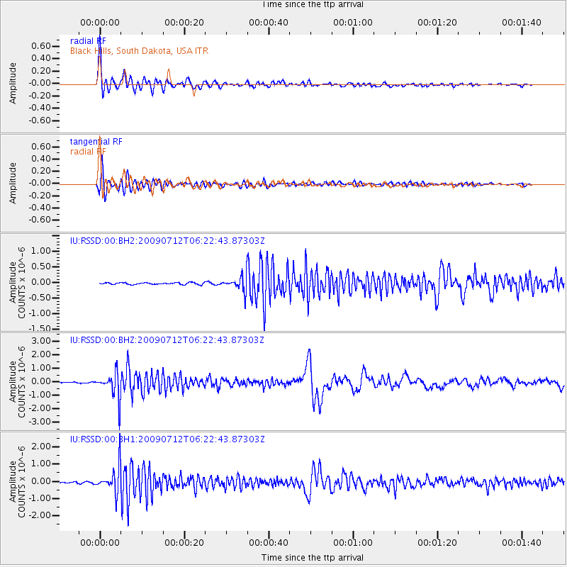
RSSD Black Hills, South Dakota, USA - Earthquake Result Viewer
*The percent match for this event was below the threshold and hence no stack was calculated.
| Earthquake location: |
Southern Peru |
| Earthquake latitude/longitude: |
-15.0/-70.4 |
| Earthquake time(UTC): |
2009/07/12 (193) 06:12:47 GMT |
| Earthquake Depth: |
199 km |
| Earthquake Magnitude: |
5.7 MB, 6.1 MW, 6.1 MW |
| Earthquake Catalog/Contributor: |
WHDF/NEIC |
|
| Network: |
IU Global Seismograph Network (GSN - IRIS/USGS) |
| Station: |
RSSD Black Hills, South Dakota, USA |
| Lat/Lon: |
44.12 N/104.04 W |
| Elevation: |
2060 m |
|
| Distance: |
66.4 deg |
| Az: |
334.22 deg |
| Baz: |
144.307 deg |
| Ray Param: |
$rayparam |
*The percent match for this event was below the threshold and hence was not used in the summary stack. |
|
| Radial Match: |
94.67819 % |
| Radial Bump: |
400 |
| Transverse Match: |
90.62866 % |
| Transverse Bump: |
400 |
| SOD ConfigId: |
590571 |
| Insert Time: |
2013-09-27 16:18:27.388 +0000 |
| GWidth: |
2.5 |
| Max Bumps: |
400 |
| Tol: |
0.001 |
|
Signal To Noise
| Channel | StoN | STA | LTA |
| IU:RSSD:00:BHZ:20090712T06:22:43.87303Z | 19.284576 | 9.3649714E-7 | 4.8561976E-8 |
| IU:RSSD:00:BH1:20090712T06:22:43.87303Z | 20.366226 | 7.696343E-7 | 3.7789736E-8 |
| IU:RSSD:00:BH2:20090712T06:22:43.87303Z | 8.26587 | 2.3708358E-7 | 2.8682228E-8 |
| Arrivals |
| Ps | |
| PpPs | |
| PsPs/PpSs | |


