You are here: Home > Network List > IU - Global Seismograph Network (GSN - IRIS/USGS) Stations List
> Station RSSD Black Hills, South Dakota, USA > Earthquake Result Viewer
RSSD Black Hills, South Dakota, USA - Earthquake Result Viewer
| Earthquake location: |
Southeast Of Honshu, Japan |
| Earthquake latitude/longitude: |
32.8/140.4 |
| Earthquake time(UTC): |
2009/08/12 (224) 22:48:51 GMT |
| Earthquake Depth: |
53 km |
| Earthquake Magnitude: |
6.2 MB, 6.6 MW, 6.6 MW |
| Earthquake Catalog/Contributor: |
WHDF/NEIC |
|
| Network: |
IU Global Seismograph Network (GSN - IRIS/USGS) |
| Station: |
RSSD Black Hills, South Dakota, USA |
| Lat/Lon: |
44.12 N/104.04 W |
| Elevation: |
2060 m |
|
| Distance: |
83.5 deg |
| Az: |
40.831 deg |
| Baz: |
310.145 deg |
| Ray Param: |
0.0460208 |
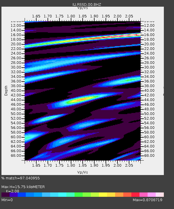
| Estimated Moho Depth: |
15.75 km |
| Estimated Crust Vp/Vs: |
2.08 |
| Assumed Crust Vp: |
6.242 km/s |
| Estimated Crust Vs: |
3.001 km/s |
| Estimated Crust Poisson's Ratio: |
0.35 |
|
| Radial Match: |
97.040955 % |
| Radial Bump: |
379 |
| Transverse Match: |
90.14369 % |
| Transverse Bump: |
400 |
| SOD ConfigId: |
617450 |
| Insert Time: |
2013-09-30 14:01:16.779 +0000 |
| GWidth: |
2.5 |
| Max Bumps: |
400 |
| Tol: |
0.001 |
|
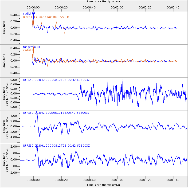
Signal To Noise
| Channel | StoN | STA | LTA |
| IU:RSSD:00:BHZ:20090812T23:00:42.623003Z | 53.507526 | 2.6452612E-6 | 4.9437183E-8 |
| IU:RSSD:00:BH1:20090812T23:00:42.623003Z | 20.662897 | 1.0460477E-6 | 5.0624447E-8 |
| IU:RSSD:00:BH2:20090812T23:00:42.623003Z | 5.917723 | 2.4401263E-7 | 4.123421E-8 |
| Arrivals |
| Ps | 2.8 SECOND |
| PpPs | 7.6 SECOND |
| PsPs/PpSs | 10 SECOND |


