You are here: Home > Network List > II - Global Seismograph Network (GSN - IRIS/IDA) Stations List
> Station MSEY Mahe, Seychelles > Earthquake Result Viewer
MSEY Mahe, Seychelles - Earthquake Result Viewer
| Earthquake location: |
Near S. Coast Of Honshu, Japan |
| Earthquake latitude/longitude: |
33.2/137.9 |
| Earthquake time(UTC): |
2009/08/09 (221) 10:55:55 GMT |
| Earthquake Depth: |
297 km |
| Earthquake Magnitude: |
6.5 MB, 7.1 MW, 7.1 MW |
| Earthquake Catalog/Contributor: |
WHDF/NEIC |
|
| Network: |
II Global Seismograph Network (GSN - IRIS/IDA) |
| Station: |
MSEY Mahe, Seychelles |
| Lat/Lon: |
4.67 S/55.48 E |
| Elevation: |
475 m |
|
| Distance: |
86.2 deg |
| Az: |
261.988 deg |
| Baz: |
56.439 deg |
| Ray Param: |
0.04345204 |
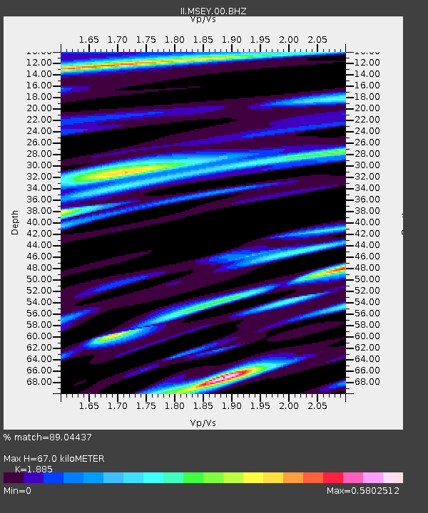
| Estimated Moho Depth: |
67.0 km |
| Estimated Crust Vp/Vs: |
1.88 |
| Assumed Crust Vp: |
6.303 km/s |
| Estimated Crust Vs: |
3.344 km/s |
| Estimated Crust Poisson's Ratio: |
0.30 |
|
| Radial Match: |
89.04437 % |
| Radial Bump: |
400 |
| Transverse Match: |
80.55054 % |
| Transverse Bump: |
400 |
| SOD ConfigId: |
617450 |
| Insert Time: |
2013-09-30 14:03:54.438 +0000 |
| GWidth: |
2.5 |
| Max Bumps: |
400 |
| Tol: |
0.001 |
|
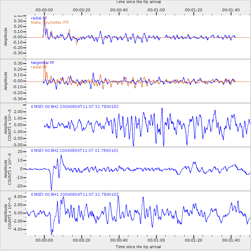
Signal To Noise
| Channel | StoN | STA | LTA |
| II:MSEY:00:BHZ:20090809T11:07:32.789016Z | 19.017374 | 8.516406E-6 | 4.4782237E-7 |
| II:MSEY:00:BH1:20090809T11:07:32.789016Z | 6.048282 | 2.2230142E-6 | 3.6754474E-7 |
| II:MSEY:00:BH2:20090809T11:07:32.789016Z | 1.1513597 | 4.6336507E-7 | 4.024503E-7 |
| Arrivals |
| Ps | 9.6 SECOND |
| PpPs | 30 SECOND |
| PsPs/PpSs | 40 SECOND |


