You are here: Home > Network List > US - United States National Seismic Network Stations List
> Station KSU1 Kansas State University--Konza Prairie, Kansas, USA > Earthquake Result Viewer
KSU1 Kansas State University--Konza Prairie, Kansas, USA - Earthquake Result Viewer
| Earthquake location: |
Near S. Coast Of Honshu, Japan |
| Earthquake latitude/longitude: |
33.2/137.9 |
| Earthquake time(UTC): |
2009/08/09 (221) 10:55:55 GMT |
| Earthquake Depth: |
297 km |
| Earthquake Magnitude: |
6.5 MB, 7.1 MW, 7.1 MW |
| Earthquake Catalog/Contributor: |
WHDF/NEIC |
|
| Network: |
US United States National Seismic Network |
| Station: |
KSU1 Kansas State University--Konza Prairie, Kansas, USA |
| Lat/Lon: |
39.10 N/96.61 W |
| Elevation: |
347 m |
|
| Distance: |
92.1 deg |
| Az: |
39.367 deg |
| Baz: |
316.864 deg |
| Ray Param: |
0.041336525 |
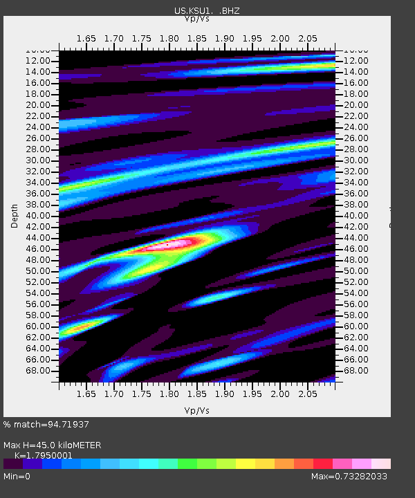
| Estimated Moho Depth: |
45.0 km |
| Estimated Crust Vp/Vs: |
1.80 |
| Assumed Crust Vp: |
6.483 km/s |
| Estimated Crust Vs: |
3.611 km/s |
| Estimated Crust Poisson's Ratio: |
0.27 |
|
| Radial Match: |
94.71937 % |
| Radial Bump: |
400 |
| Transverse Match: |
85.56622 % |
| Transverse Bump: |
400 |
| SOD ConfigId: |
617450 |
| Insert Time: |
2013-09-30 14:04:30.730 +0000 |
| GWidth: |
2.5 |
| Max Bumps: |
400 |
| Tol: |
0.001 |
|
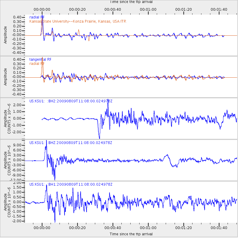
Signal To Noise
| Channel | StoN | STA | LTA |
| US:KSU1: :BHZ:20090809T11:08:00.024978Z | 60.048447 | 3.9864826E-6 | 6.638777E-8 |
| US:KSU1: :BH1:20090809T11:08:00.024978Z | 10.3891735 | 6.605242E-7 | 6.357813E-8 |
| US:KSU1: :BH2:20090809T11:08:00.024978Z | 12.174371 | 1.128315E-6 | 9.2679535E-8 |
| Arrivals |
| Ps | 5.6 SECOND |
| PpPs | 19 SECOND |
| PsPs/PpSs | 25 SECOND |


