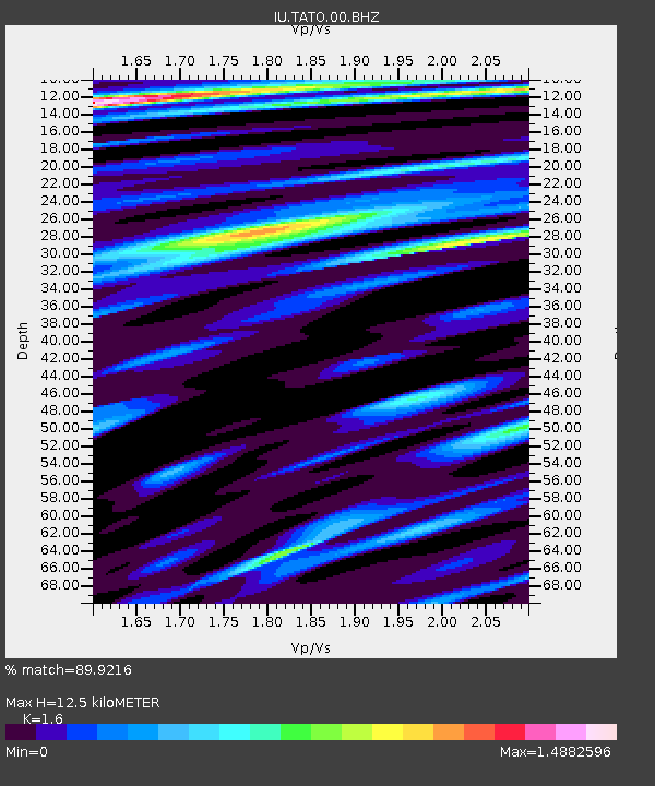
TATO Taipei, Taiwan - Earthquake Result Viewer

Earthquake location: Southern Sumatra, Indonesia
Earthquake latitude/longitude: -1.5/99.5
Earthquake time(UTC): 2009/08/16 (228) 07:38:21 GMT
Earthquake Depth: 20 km
Earthquake Magnitude: 6.5 MB, 6.7 MS, 6.7 MW, 6.5 MW
Earthquake Catalog/Contributor: WHDF/NEIC
Network: IU Global Seismograph Network (GSN - IRIS/USGS)
Station: TATO Taipei, Taiwan
Lat/Lon: 24.98 N/121.49 E
Elevation: 53 m
Distance: 33.9 deg
Az: 37.606 deg
Baz: 222.234 deg
Ray Param: 0.077994555
Estimated Moho Depth: 12.5 km
Estimated Crust Vp/Vs: 1.60
Assumed Crust Vp: 6.289 km/s
Estimated Crust Vs: 3.93 km/s
Estimated Crust Poisson's Ratio: 0.18
Radial Match: 89.9216 %
Radial Bump: 400
Transverse Match: 90.23559 %
Transverse Bump: 400
SOD ConfigId: 617450
Insert Time: 2013-09-30 14:11:25.542 +0000
GWidth: 2.5
Max Bumps: 400
Tol: 0.001

Signal To Noise

ChannelStoNSTALTA
IU:TATO:00:BHZ:20090816T07:44:32.147998Z3.65944866.8064446E-71.8599644E-7
IU:TATO:00:BH1:20090816T07:44:32.147998Z1.62183684.3912266E-72.7075637E-7
IU:TATO:00:BH2:20090816T07:44:32.147998Z1.78763094.1123997E-72.3004746E-7
Arrivals
Ps1.3 SECOND
PpPs4.8 SECOND
PsPs/PpSs6.1 SECOND