You are here: Home > Network List > TA - USArray Transportable Network (new EarthScope stations) Stations List
> Station 121A Cookes Peak, Deming, NM, USA > Earthquake Result Viewer
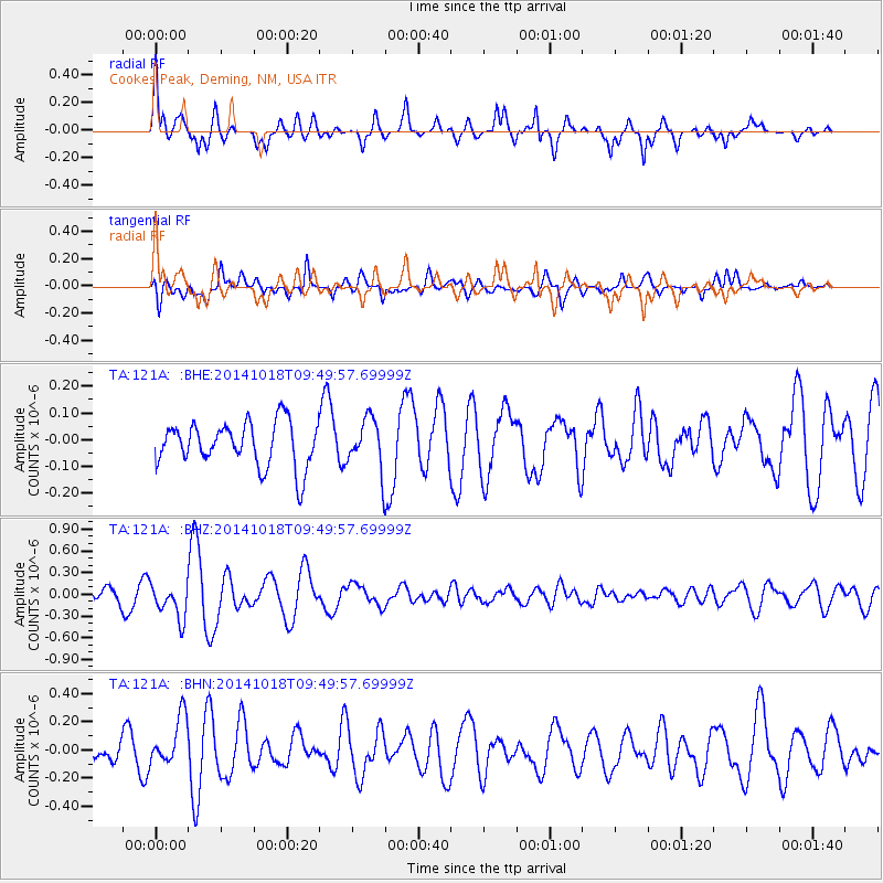
121A Cookes Peak, Deming, NM, USA - Earthquake Result Viewer
*The percent match for this event was below the threshold and hence no stack was calculated.
| Earthquake location: |
Iceland |
| Earthquake latitude/longitude: |
64.5/-17.6 |
| Earthquake time(UTC): |
2014/10/18 (291) 09:40:12 GMT |
| Earthquake Depth: |
4.7 km |
| Earthquake Magnitude: |
5.3 MW |
| Earthquake Catalog/Contributor: |
ISC/ISC |
|
| Network: |
TA USArray Transportable Network (new EarthScope stations) |
| Station: |
121A Cookes Peak, Deming, NM, USA |
| Lat/Lon: |
32.53 N/107.79 W |
| Elevation: |
1652 m |
|
| Distance: |
61.2 deg |
| Az: |
285.48 deg |
| Baz: |
29.558 deg |
| Ray Param: |
$rayparam |
*The percent match for this event was below the threshold and hence was not used in the summary stack. |
|
| Radial Match: |
67.959305 % |
| Radial Bump: |
400 |
| Transverse Match: |
58.67842 % |
| Transverse Bump: |
400 |
| SOD ConfigId: |
3390531 |
| Insert Time: |
2019-04-14 14:48:03.810 +0000 |
| GWidth: |
2.5 |
| Max Bumps: |
400 |
| Tol: |
0.001 |
|
Signal To Noise
| Channel | StoN | STA | LTA |
| TA:121A: :BHZ:20141018T09:49:57.69999Z | 2.169779 | 2.3807274E-7 | 1.0972211E-7 |
| TA:121A: :BHN:20141018T09:49:57.69999Z | 1.3703982 | 1.7343706E-7 | 1.2655961E-7 |
| TA:121A: :BHE:20141018T09:49:57.69999Z | 1.1458662 | 9.516685E-8 | 8.305233E-8 |
| Arrivals |
| Ps | |
| PpPs | |
| PsPs/PpSs | |


