You are here: Home > Network List > TA - USArray Transportable Network (new EarthScope stations) Stations List
> Station MSTX Muleshoe, TX, USA > Earthquake Result Viewer
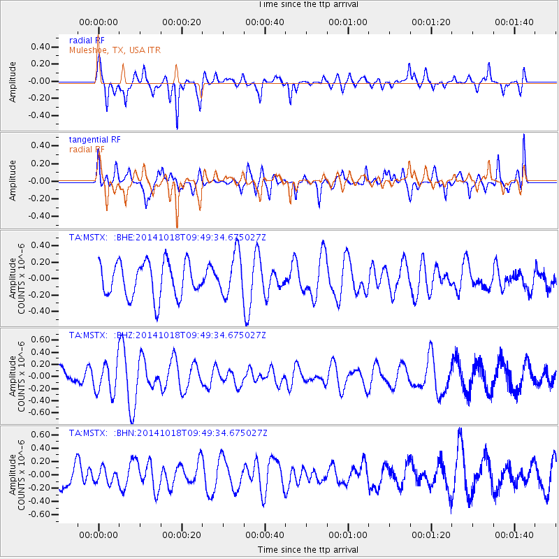
MSTX Muleshoe, TX, USA - Earthquake Result Viewer
*The percent match for this event was below the threshold and hence no stack was calculated.
| Earthquake location: |
Iceland |
| Earthquake latitude/longitude: |
64.5/-17.6 |
| Earthquake time(UTC): |
2014/10/18 (291) 09:40:12 GMT |
| Earthquake Depth: |
4.7 km |
| Earthquake Magnitude: |
5.3 MW |
| Earthquake Catalog/Contributor: |
ISC/ISC |
|
| Network: |
TA USArray Transportable Network (new EarthScope stations) |
| Station: |
MSTX Muleshoe, TX, USA |
| Lat/Lon: |
33.97 N/102.77 W |
| Elevation: |
1167 m |
|
| Distance: |
57.9 deg |
| Az: |
282.097 deg |
| Baz: |
30.579 deg |
| Ray Param: |
$rayparam |
*The percent match for this event was below the threshold and hence was not used in the summary stack. |
|
| Radial Match: |
73.706184 % |
| Radial Bump: |
400 |
| Transverse Match: |
62.78185 % |
| Transverse Bump: |
400 |
| SOD ConfigId: |
3390531 |
| Insert Time: |
2019-04-14 14:48:38.993 +0000 |
| GWidth: |
2.5 |
| Max Bumps: |
400 |
| Tol: |
0.001 |
|
Signal To Noise
| Channel | StoN | STA | LTA |
| TA:MSTX: :BHZ:20141018T09:49:34.675027Z | 2.0453105 | 2.7077783E-7 | 1.3238959E-7 |
| TA:MSTX: :BHN:20141018T09:49:34.675027Z | 0.63974726 | 1.06346114E-7 | 1.6623146E-7 |
| TA:MSTX: :BHE:20141018T09:49:34.675027Z | 1.2575029 | 2.6766406E-7 | 2.1285365E-7 |
| Arrivals |
| Ps | |
| PpPs | |
| PsPs/PpSs | |


