You are here: Home > Network List > TA - USArray Transportable Network (new EarthScope stations) Stations List
> Station R11A Troy Canyon, Currant, NV, USA > Earthquake Result Viewer
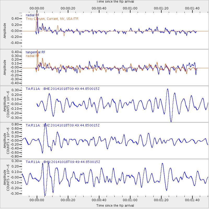
R11A Troy Canyon, Currant, NV, USA - Earthquake Result Viewer
*The percent match for this event was below the threshold and hence no stack was calculated.
| Earthquake location: |
Iceland |
| Earthquake latitude/longitude: |
64.5/-17.6 |
| Earthquake time(UTC): |
2014/10/18 (291) 09:40:12 GMT |
| Earthquake Depth: |
4.7 km |
| Earthquake Magnitude: |
5.3 MW |
| Earthquake Catalog/Contributor: |
ISC/ISC |
|
| Network: |
TA USArray Transportable Network (new EarthScope stations) |
| Station: |
R11A Troy Canyon, Currant, NV, USA |
| Lat/Lon: |
38.35 N/115.59 W |
| Elevation: |
1756 m |
|
| Distance: |
59.3 deg |
| Az: |
295.159 deg |
| Baz: |
29.852 deg |
| Ray Param: |
$rayparam |
*The percent match for this event was below the threshold and hence was not used in the summary stack. |
|
| Radial Match: |
45.929348 % |
| Radial Bump: |
400 |
| Transverse Match: |
60.660767 % |
| Transverse Bump: |
400 |
| SOD ConfigId: |
3390531 |
| Insert Time: |
2019-04-14 14:48:49.653 +0000 |
| GWidth: |
2.5 |
| Max Bumps: |
400 |
| Tol: |
0.001 |
|
Signal To Noise
| Channel | StoN | STA | LTA |
| TA:R11A: :BHZ:20141018T09:49:44.850015Z | 2.289078 | 2.6479216E-7 | 1.15676336E-7 |
| TA:R11A: :BHN:20141018T09:49:44.850015Z | 1.9152448 | 1.1600919E-7 | 6.0571466E-8 |
| TA:R11A: :BHE:20141018T09:49:44.850015Z | 0.6925626 | 7.279317E-8 | 1.05107E-7 |
| Arrivals |
| Ps | |
| PpPs | |
| PsPs/PpSs | |


