You are here: Home > Network List > IU - Global Seismograph Network (GSN - IRIS/USGS) Stations List
> Station OTAV Otavalo, Ecuador > Earthquake Result Viewer
OTAV Otavalo, Ecuador - Earthquake Result Viewer
| Earthquake location: |
Gulf Of California |
| Earthquake latitude/longitude: |
29.0/-112.9 |
| Earthquake time(UTC): |
2009/08/03 (215) 17:59:56 GMT |
| Earthquake Depth: |
10 km |
| Earthquake Magnitude: |
6.2 MB, 6.9 MW, 6.8 MW |
| Earthquake Catalog/Contributor: |
WHDF/NEIC |
|
| Network: |
IU Global Seismograph Network (GSN - IRIS/USGS) |
| Station: |
OTAV Otavalo, Ecuador |
| Lat/Lon: |
0.24 N/78.45 W |
| Elevation: |
3510 m |
|
| Distance: |
43.6 deg |
| Az: |
124.897 deg |
| Baz: |
314.093 deg |
| Ray Param: |
0.072441556 |
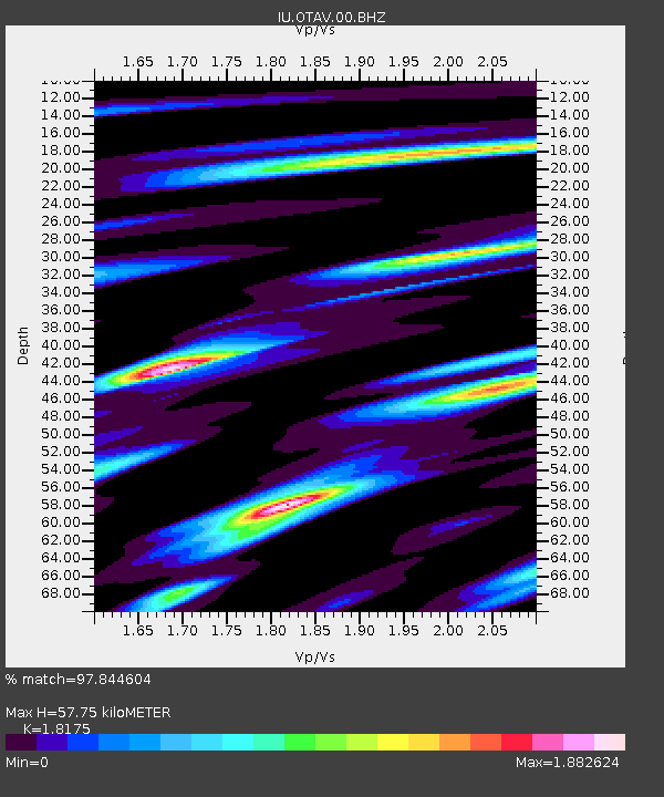
| Estimated Moho Depth: |
57.75 km |
| Estimated Crust Vp/Vs: |
1.82 |
| Assumed Crust Vp: |
6.472 km/s |
| Estimated Crust Vs: |
3.561 km/s |
| Estimated Crust Poisson's Ratio: |
0.28 |
|
| Radial Match: |
97.844604 % |
| Radial Bump: |
322 |
| Transverse Match: |
86.88795 % |
| Transverse Bump: |
400 |
| SOD ConfigId: |
617450 |
| Insert Time: |
2013-09-30 14:42:28.282 +0000 |
| GWidth: |
2.5 |
| Max Bumps: |
400 |
| Tol: |
0.001 |
|
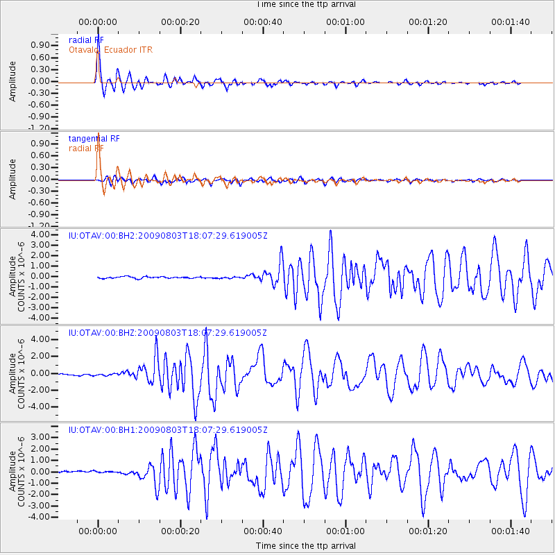
Signal To Noise
| Channel | StoN | STA | LTA |
| IU:OTAV:00:BHZ:20090803T18:07:29.619005Z | 1.0272255 | 1.0233182E-7 | 9.961963E-8 |
| IU:OTAV:00:BH1:20090803T18:07:29.619005Z | 1.010296 | 1.3322024E-7 | 1.3186258E-7 |
| IU:OTAV:00:BH2:20090803T18:07:29.619005Z | 0.82128453 | 6.580773E-8 | 8.012781E-8 |
| Arrivals |
| Ps | 7.8 SECOND |
| PpPs | 24 SECOND |
| PsPs/PpSs | 31 SECOND |


