You are here: Home > Network List > TA - USArray Transportable Network (new EarthScope stations) Stations List
> Station X43A Marvell, AR, USA > Earthquake Result Viewer
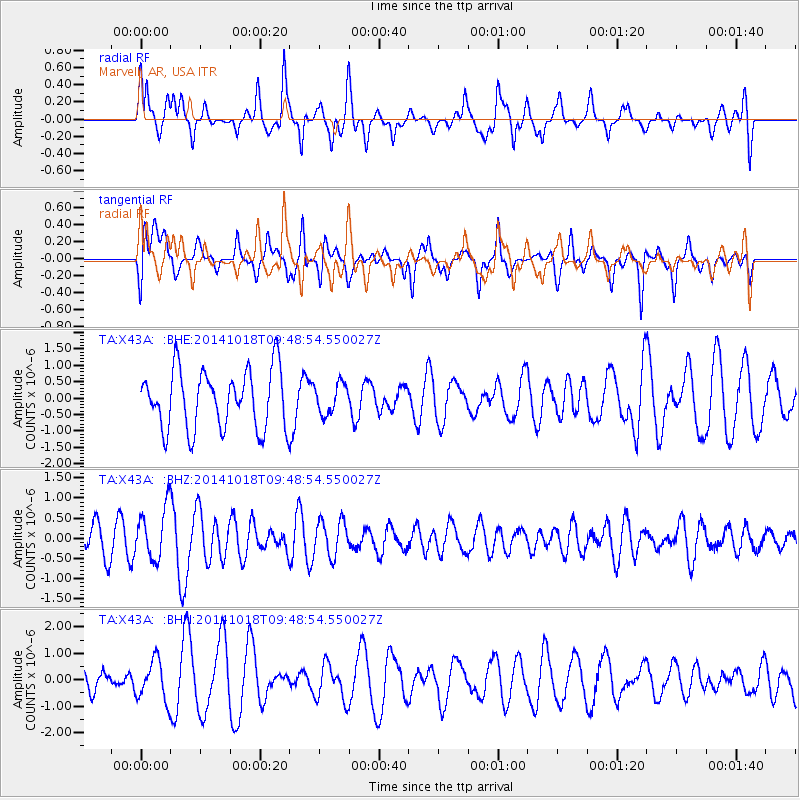
X43A Marvell, AR, USA - Earthquake Result Viewer
*The percent match for this event was below the threshold and hence no stack was calculated.
| Earthquake location: |
Iceland |
| Earthquake latitude/longitude: |
64.5/-17.6 |
| Earthquake time(UTC): |
2014/10/18 (291) 09:40:12 GMT |
| Earthquake Depth: |
4.7 km |
| Earthquake Magnitude: |
5.3 MW |
| Earthquake Catalog/Contributor: |
ISC/ISC |
|
| Network: |
TA USArray Transportable Network (new EarthScope stations) |
| Station: |
X43A Marvell, AR, USA |
| Lat/Lon: |
34.52 N/90.88 W |
| Elevation: |
53 m |
|
| Distance: |
52.3 deg |
| Az: |
272.157 deg |
| Baz: |
31.553 deg |
| Ray Param: |
$rayparam |
*The percent match for this event was below the threshold and hence was not used in the summary stack. |
|
| Radial Match: |
66.77233 % |
| Radial Bump: |
400 |
| Transverse Match: |
53.85997 % |
| Transverse Bump: |
400 |
| SOD ConfigId: |
3390531 |
| Insert Time: |
2019-04-14 14:49:09.525 +0000 |
| GWidth: |
2.5 |
| Max Bumps: |
400 |
| Tol: |
0.001 |
|
Signal To Noise
| Channel | StoN | STA | LTA |
| TA:X43A: :BHZ:20141018T09:48:54.550027Z | 1.9605925 | 6.459604E-7 | 3.2947204E-7 |
| TA:X43A: :BHN:20141018T09:48:54.550027Z | 2.2082047 | 7.6173603E-7 | 3.4495716E-7 |
| TA:X43A: :BHE:20141018T09:48:54.550027Z | 0.51051664 | 4.5786447E-7 | 8.96865E-7 |
| Arrivals |
| Ps | |
| PpPs | |
| PsPs/PpSs | |


