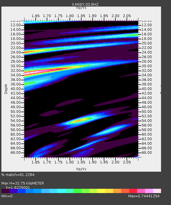
MSEY Mahe, Seychelles - Earthquake Result Viewer
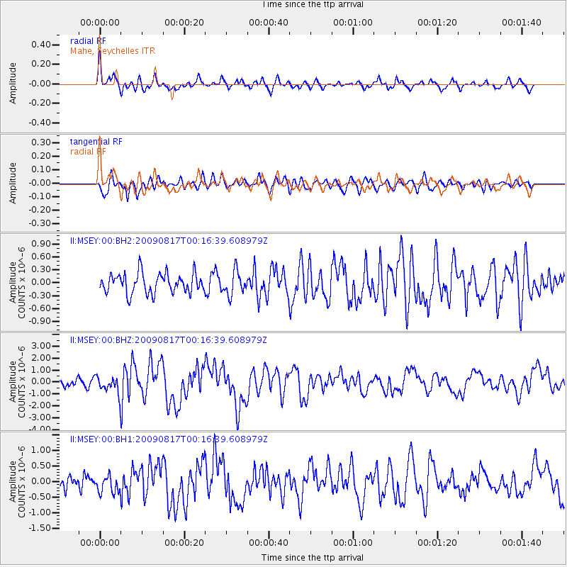
Earthquake location: Southwestern Ryukyu Isl., Japan
Earthquake latitude/longitude: 23.5/123.5
Earthquake time(UTC): 2009/08/17 (229) 00:05:49 GMT
Earthquake Depth: 20 km
Earthquake Magnitude: 6.2 MB, 6.6 MS, 6.7 MW, 6.6 MW
Earthquake Catalog/Contributor: WHDF/NEIC
Network: II Global Seismograph Network (GSN - IRIS/IDA)
Station: MSEY Mahe, Seychelles
Lat/Lon: 4.67 S/55.48 E
Elevation: 475 m
Distance: 71.9 deg
Az: 256.481 deg
Baz: 63.576 deg
Ray Param: 0.05398778
Estimated Moho Depth: 32.75 km
Estimated Crust Vp/Vs: 1.62
Assumed Crust Vp: 6.303 km/s
Estimated Crust Vs: 3.884 km/s
Estimated Crust Poisson's Ratio: 0.19
Radial Match: 81.2294 %
Radial Bump: 394
Transverse Match: 68.115524 %
Transverse Bump: 400
SOD ConfigId: 617450
Insert Time: 2013-09-30 14:55:14.834 +0000
GWidth: 2.5
Max Bumps: 400
Tol: 0.001

Signal To Noise

ChannelStoNSTALTA
II:MSEY:00:BHZ:20090817T00:16:39.608979Z2.89313537.7159336E-72.66698E-7
II:MSEY:00:BH1:20090817T00:16:39.608979Z1.5001952.9449322E-71.9630329E-7
II:MSEY:00:BH2:20090817T00:16:39.608979Z1.21542452.7632555E-72.27349E-7
Arrivals
Ps3.4 SECOND
PpPs13 SECOND
PsPs/PpSs16 SECOND