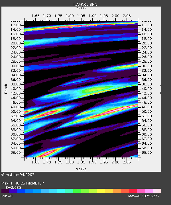
AAK Ala Archa, Kyrgyzstan - Earthquake Result Viewer
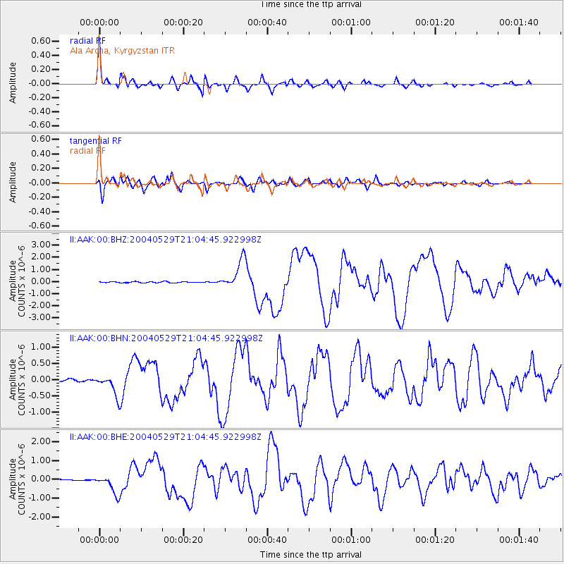
Earthquake location: Off East Coast Of Honshu, Japan
Earthquake latitude/longitude: 34.3/141.4
Earthquake time(UTC): 2004/05/29 (150) 20:56:09 GMT
Earthquake Depth: 16 km
Earthquake Magnitude: 5.6 MB, 6.6 MS, 6.5 MW, 6.3 MW
Earthquake Catalog/Contributor: WHDF/NEIC
Network: II Global Seismograph Network (GSN - IRIS/IDA)
Station: AAK Ala Archa, Kyrgyzstan
Lat/Lon: 42.64 N/74.49 E
Elevation: 1645 m
Distance: 51.8 deg
Az: 300.318 deg
Baz: 75.704 deg
Ray Param: 0.067131124
Estimated Moho Depth: 48.25 km
Estimated Crust Vp/Vs: 2.04
Assumed Crust Vp: 6.306 km/s
Estimated Crust Vs: 3.099 km/s
Estimated Crust Poisson's Ratio: 0.34
Radial Match: 94.9207 %
Radial Bump: 400
Transverse Match: 91.783936 %
Transverse Bump: 400
SOD ConfigId: 2459
Insert Time: 2010-03-01 15:26:04.400 +0000
GWidth: 2.5
Max Bumps: 400
Tol: 0.001

Signal To Noise

ChannelStoNSTALTA
II:AAK:00:BHN:20040529T21:04:45.922998Z10.2501953.296124E-73.2156695E-8
II:AAK:00:BHE:20040529T21:04:45.922998Z16.809935.3526827E-73.1842383E-8
II:AAK:00:BHZ:20040529T21:04:45.922998Z29.6359751.2522765E-64.2255287E-8
Arrivals
Ps8.3 SECOND
PpPs22 SECOND
PsPs/PpSs30 SECOND