You are here: Home > Network List > IU - Global Seismograph Network (GSN - IRIS/USGS) Stations List
> Station RSSD Black Hills, South Dakota, USA > Earthquake Result Viewer
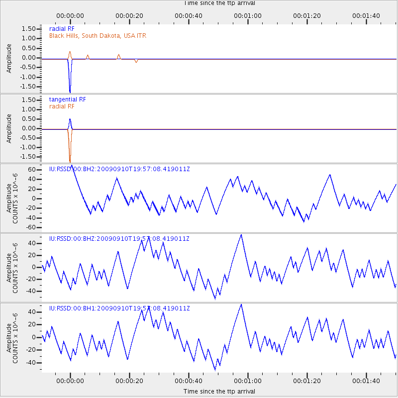
RSSD Black Hills, South Dakota, USA - Earthquake Result Viewer
*The percent match for this event was below the threshold and hence no stack was calculated.
| Earthquake location: |
Easter Island Region |
| Earthquake latitude/longitude: |
-29.9/-111.8 |
| Earthquake time(UTC): |
2009/09/10 (253) 19:46:03 GMT |
| Earthquake Depth: |
10 km |
| Earthquake Magnitude: |
5.5 MW, 5.4 MB |
| Earthquake Catalog/Contributor: |
WHDF/NEIC |
|
| Network: |
IU Global Seismograph Network (GSN - IRIS/USGS) |
| Station: |
RSSD Black Hills, South Dakota, USA |
| Lat/Lon: |
44.12 N/104.04 W |
| Elevation: |
2090 m |
|
| Distance: |
74.0 deg |
| Az: |
5.826 deg |
| Baz: |
187.028 deg |
| Ray Param: |
$rayparam |
*The percent match for this event was below the threshold and hence was not used in the summary stack. |
|
| Radial Match: |
99.99164 % |
| Radial Bump: |
2 |
| Transverse Match: |
99.94056 % |
| Transverse Bump: |
3 |
| SOD ConfigId: |
617450 |
| Insert Time: |
2013-09-30 15:46:14.755 +0000 |
| GWidth: |
2.5 |
| Max Bumps: |
400 |
| Tol: |
0.001 |
|
Signal To Noise
| Channel | StoN | STA | LTA |
| IU:RSSD:00:BHZ:20090910T19:57:08.419011Z | 1.0744164 | 2.7436476E-5 | 2.5536165E-5 |
| IU:RSSD:00:BH1:20090910T19:57:08.419011Z | 1.0744637 | 2.6521595E-5 | 2.4683564E-5 |
| IU:RSSD:00:BH2:20090910T19:57:08.419011Z | 1.0757853 | 2.5281648E-5 | 2.3500643E-5 |
| Arrivals |
| Ps | |
| PpPs | |
| PsPs/PpSs | |


