You are here: Home > Network List > IU - Global Seismograph Network (GSN - IRIS/USGS) Stations List
> Station RSSD Black Hills, South Dakota, USA > Earthquake Result Viewer
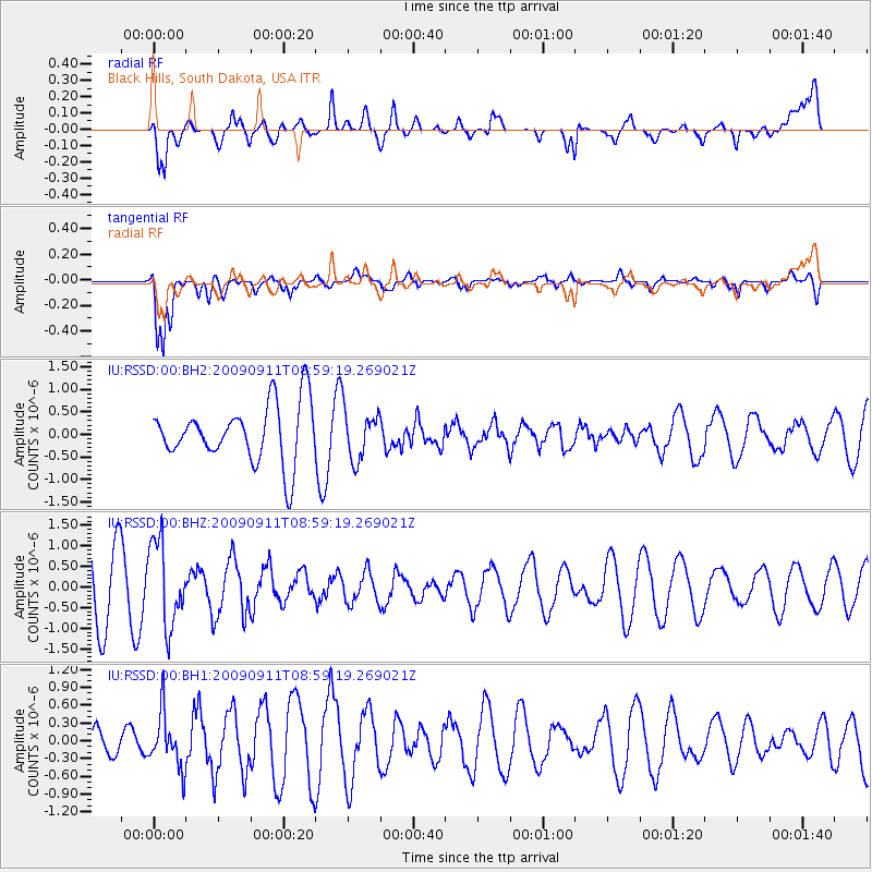
RSSD Black Hills, South Dakota, USA - Earthquake Result Viewer
*The percent match for this event was below the threshold and hence no stack was calculated.
| Earthquake location: |
Kuril Islands |
| Earthquake latitude/longitude: |
48.3/154.2 |
| Earthquake time(UTC): |
2009/09/11 (254) 08:49:11 GMT |
| Earthquake Depth: |
35 km |
| Earthquake Magnitude: |
5.8 MB, 5.0 MS, 5.6 MW, 5.6 MW |
| Earthquake Catalog/Contributor: |
WHDF/NEIC |
|
| Network: |
IU Global Seismograph Network (GSN - IRIS/USGS) |
| Station: |
RSSD Black Hills, South Dakota, USA |
| Lat/Lon: |
44.12 N/104.04 W |
| Elevation: |
2090 m |
|
| Distance: |
65.3 deg |
| Az: |
50.936 deg |
| Baz: |
313.95 deg |
| Ray Param: |
$rayparam |
*The percent match for this event was below the threshold and hence was not used in the summary stack. |
|
| Radial Match: |
57.79452 % |
| Radial Bump: |
400 |
| Transverse Match: |
83.77049 % |
| Transverse Bump: |
400 |
| SOD ConfigId: |
617450 |
| Insert Time: |
2013-09-30 15:48:01.619 +0000 |
| GWidth: |
2.5 |
| Max Bumps: |
400 |
| Tol: |
0.001 |
|
Signal To Noise
| Channel | StoN | STA | LTA |
| IU:RSSD:00:BHZ:20090911T08:59:19.269021Z | 1.5438805 | 1.0195305E-6 | 6.603688E-7 |
| IU:RSSD:00:BH1:20090911T08:59:19.269021Z | 1.3501341 | 4.5921007E-7 | 3.4012183E-7 |
| IU:RSSD:00:BH2:20090911T08:59:19.269021Z | 0.8602116 | 5.5304616E-7 | 6.4291874E-7 |
| Arrivals |
| Ps | |
| PpPs | |
| PsPs/PpSs | |


