You are here: Home > Network List > IU - Global Seismograph Network (GSN - IRIS/USGS) Stations List
> Station RSSD Black Hills, South Dakota, USA > Earthquake Result Viewer
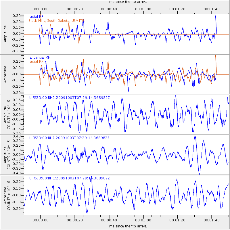
RSSD Black Hills, South Dakota, USA - Earthquake Result Viewer
*The percent match for this event was below the threshold and hence no stack was calculated.
| Earthquake location: |
Samoa Islands Region |
| Earthquake latitude/longitude: |
-16.9/-173.0 |
| Earthquake time(UTC): |
2009/10/03 (276) 07:16:59 GMT |
| Earthquake Depth: |
10 km |
| Earthquake Magnitude: |
5.5 MW |
| Earthquake Catalog/Contributor: |
NEIC PDE/NEIC PDE-M |
|
| Network: |
IU Global Seismograph Network (GSN - IRIS/USGS) |
| Station: |
RSSD Black Hills, South Dakota, USA |
| Lat/Lon: |
44.12 N/104.04 W |
| Elevation: |
2090 m |
|
| Distance: |
87.3 deg |
| Az: |
42.283 deg |
| Baz: |
243.417 deg |
| Ray Param: |
$rayparam |
*The percent match for this event was below the threshold and hence was not used in the summary stack. |
|
| Radial Match: |
44.41941 % |
| Radial Bump: |
400 |
| Transverse Match: |
55.866074 % |
| Transverse Bump: |
400 |
| SOD ConfigId: |
617450 |
| Insert Time: |
2013-09-30 16:47:01.181 +0000 |
| GWidth: |
2.5 |
| Max Bumps: |
400 |
| Tol: |
0.001 |
|
Signal To Noise
| Channel | StoN | STA | LTA |
| IU:RSSD:00:BHZ:20091003T07:29:14.368982Z | 1.9227926 | 1.8479288E-7 | 9.610651E-8 |
| IU:RSSD:00:BH1:20091003T07:29:14.368982Z | 0.7004945 | 7.979648E-8 | 1.13914496E-7 |
| IU:RSSD:00:BH2:20091003T07:29:14.368982Z | 0.99042666 | 8.3324736E-8 | 8.413014E-8 |
| Arrivals |
| Ps | |
| PpPs | |
| PsPs/PpSs | |


