You are here: Home > Network List > II - Global Seismograph Network (GSN - IRIS/IDA) Stations List
> Station PALK Pallekele, Sri Lanka > Earthquake Result Viewer
PALK Pallekele, Sri Lanka - Earthquake Result Viewer
| Earthquake location: |
Celebes Sea |
| Earthquake latitude/longitude: |
4.1/122.4 |
| Earthquake time(UTC): |
2009/10/07 (280) 21:41:13 GMT |
| Earthquake Depth: |
574 km |
| Earthquake Magnitude: |
6.3 MB, 6.8 MW, 6.8 MW |
| Earthquake Catalog/Contributor: |
WHDF/NEIC |
|
| Network: |
II Global Seismograph Network (GSN - IRIS/IDA) |
| Station: |
PALK Pallekele, Sri Lanka |
| Lat/Lon: |
7.27 N/80.70 E |
| Elevation: |
460 m |
|
| Distance: |
41.6 deg |
| Az: |
276.323 deg |
| Baz: |
92.039 deg |
| Ray Param: |
0.07078859 |
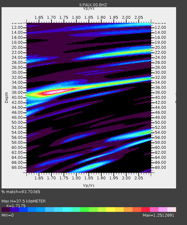
| Estimated Moho Depth: |
37.5 km |
| Estimated Crust Vp/Vs: |
1.72 |
| Assumed Crust Vp: |
6.545 km/s |
| Estimated Crust Vs: |
3.811 km/s |
| Estimated Crust Poisson's Ratio: |
0.24 |
|
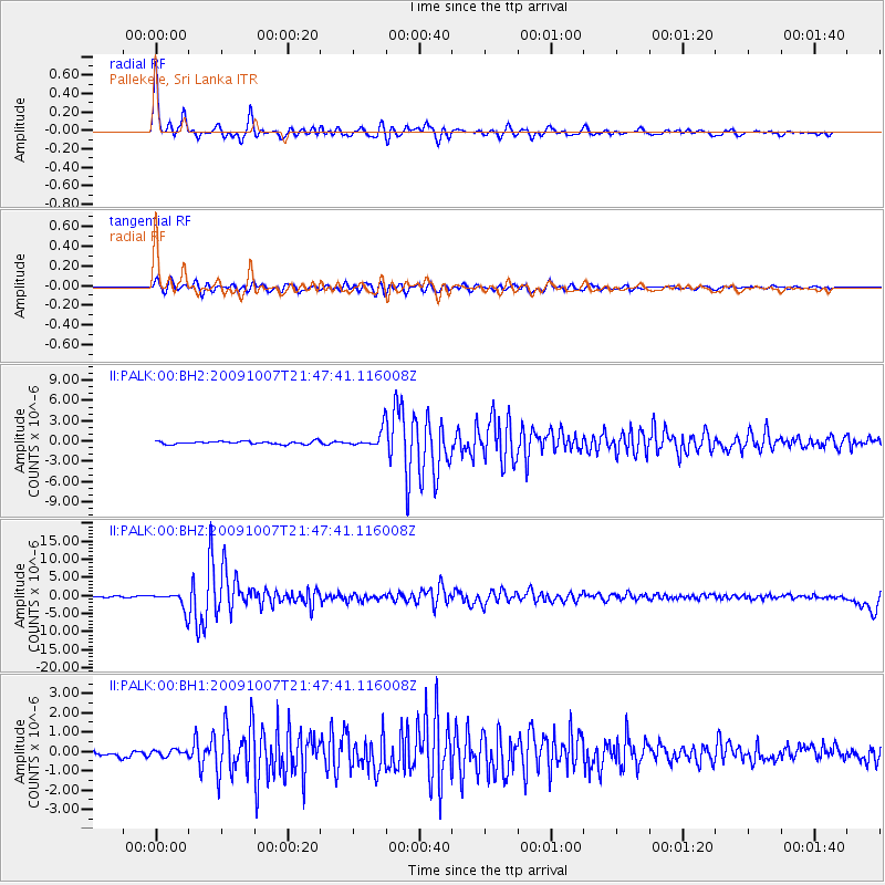
| Radial Match: |
93.70365 % |
| Radial Bump: |
400 |
| Transverse Match: |
81.941246 % |
| Transverse Bump: |
400 |
| SOD ConfigId: |
617450 |
| Insert Time: |
2013-09-30 17:04:34.933 +0000 |
| GWidth: |
2.5 |
| Max Bumps: |
400 |
| Tol: |
0.001 |
|
Signal To Noise
| Channel | StoN | STA | LTA |
| II:PALK:00:BHZ:20091007T21:47:41.116008Z | 13.1355 | 2.4282522E-6 | 1.8486179E-7 |
| II:PALK:00:BH1:20091007T21:47:41.116008Z | 0.99182975 | 1.598474E-7 | 1.6116415E-7 |
| II:PALK:00:BH2:20091007T21:47:41.116008Z | 6.0837817 | 1.3039128E-6 | 2.1432602E-7 |
| Arrivals |
| Ps | 4.4 SECOND |
| PpPs | 15 SECOND |
| PsPs/PpSs | 19 SECOND |


