You are here: Home > Network List > YB13 - Continental Dynamics/Cent. Anatolian Tectonics:Surface to Mantle Dynamics During Stations List
> Station AT56 Kaldirim,Adana,Turkey > Earthquake Result Viewer
AT56 Kaldirim,Adana,Turkey - Earthquake Result Viewer
| Earthquake location: |
Luzon, Philippines |
| Earthquake latitude/longitude: |
14.2/124.6 |
| Earthquake time(UTC): |
2014/10/19 (292) 18:14:27 GMT |
| Earthquake Depth: |
25 km |
| Earthquake Magnitude: |
4.9 MW |
| Earthquake Catalog/Contributor: |
ISC/ISC |
|
| Network: |
YB Continental Dynamics/Cent. Anatolian Tectonics:Surface to Mantle Dynamics During |
| Station: |
AT56 Kaldirim,Adana,Turkey |
| Lat/Lon: |
36.70 N/35.55 E |
| Elevation: |
76 m |
|
| Distance: |
80.9 deg |
| Az: |
305.541 deg |
| Baz: |
79.131 deg |
| Ray Param: |
0.0479014 |
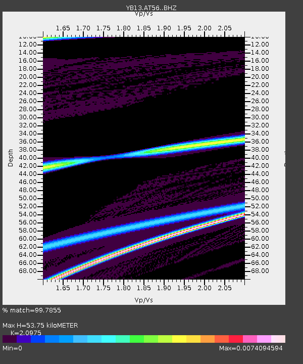
| Estimated Moho Depth: |
53.75 km |
| Estimated Crust Vp/Vs: |
2.10 |
| Assumed Crust Vp: |
6.247 km/s |
| Estimated Crust Vs: |
2.978 km/s |
| Estimated Crust Poisson's Ratio: |
0.35 |
|
| Radial Match: |
99.7855 % |
| Radial Bump: |
13 |
| Transverse Match: |
59.002712 % |
| Transverse Bump: |
400 |
| SOD ConfigId: |
3390531 |
| Insert Time: |
2019-04-14 15:08:17.527 +0000 |
| GWidth: |
2.5 |
| Max Bumps: |
400 |
| Tol: |
0.001 |
|

Signal To Noise
| Channel | StoN | STA | LTA |
| YB:AT56: :BHZ:20141019T18:26:08.379985Z | 0.3598477 | 2.691521E-7 | 7.4796117E-7 |
| YB:AT56: :BHN:20141019T18:26:08.379985Z | 6.189024 | 3.354088E-7 | 5.4194135E-8 |
| YB:AT56: :BHE:20141019T18:26:08.379985Z | 0.35903612 | 3.8765944E-7 | 1.0797227E-6 |
| Arrivals |
| Ps | 9.7 SECOND |
| PpPs | 26 SECOND |
| PsPs/PpSs | 36 SECOND |


