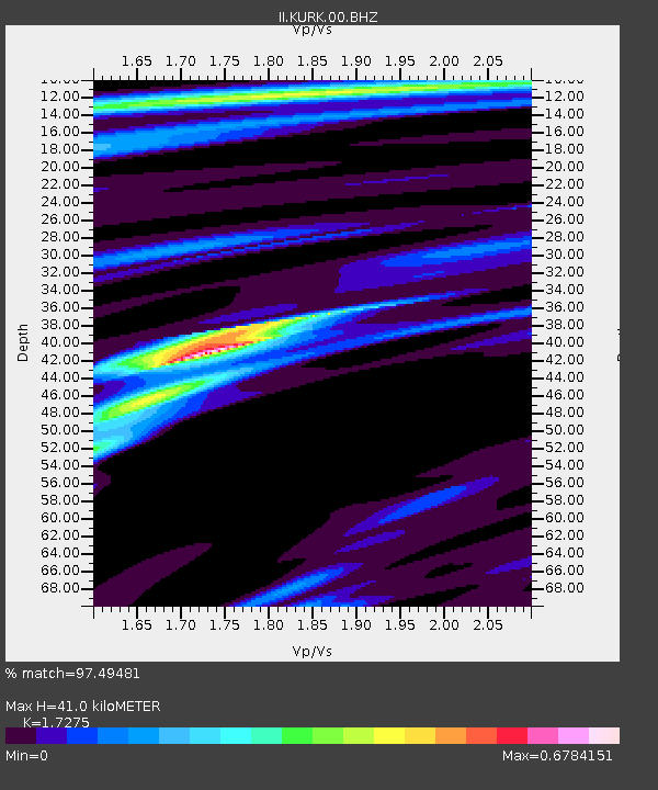
KURK Kurchatov, Kazakhstan - Earthquake Result Viewer
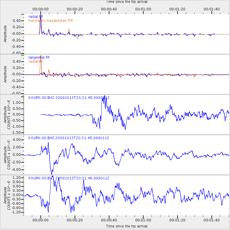
Earthquake location: Fox Islands, Aleutian Islands
Earthquake latitude/longitude: 52.6/-167.1
Earthquake time(UTC): 2009/10/13 (286) 20:21:53 GMT
Earthquake Depth: 14 km
Earthquake Magnitude: 5.9 MB, 6.4 MS, 6.4 MW, 6.4 MW
Earthquake Catalog/Contributor: WHDF/NEIC
Network: II Global Seismograph Network (GSN - IRIS/IDA)
Station: KURK Kurchatov, Kazakhstan
Lat/Lon: 50.72 N/78.62 E
Elevation: 184 m
Distance: 63.1 deg
Az: 319.467 deg
Baz: 38.571 deg
Ray Param: 0.059786465
Estimated Moho Depth: 41.0 km
Estimated Crust Vp/Vs: 1.73
Assumed Crust Vp: 6.552 km/s
Estimated Crust Vs: 3.793 km/s
Estimated Crust Poisson's Ratio: 0.25
Radial Match: 97.49481 %
Radial Bump: 291
Transverse Match: 86.259254 %
Transverse Bump: 400
SOD ConfigId: 617450
Insert Time: 2013-09-30 17:55:21.477 +0000
GWidth: 2.5
Max Bumps: 400
Tol: 0.001

Signal To Noise

ChannelStoNSTALTA
II:KURK:00:BHZ:20091013T20:31:48.999011Z20.575221.5651831E-67.607127E-8
II:KURK:00:BH1:20091013T20:31:48.999011Z13.7630935.7801446E-74.1997424E-8
II:KURK:00:BH2:20091013T20:31:48.999011Z14.6458915.692932E-73.8870507E-8
Arrivals
Ps4.8 SECOND
PpPs16 SECOND
PsPs/PpSs21 SECOND