You are here: Home > Network List > IU - Global Seismograph Network (GSN - IRIS/USGS) Stations List
> Station TEIG Tepich, Yucatan, Mexico > Earthquake Result Viewer
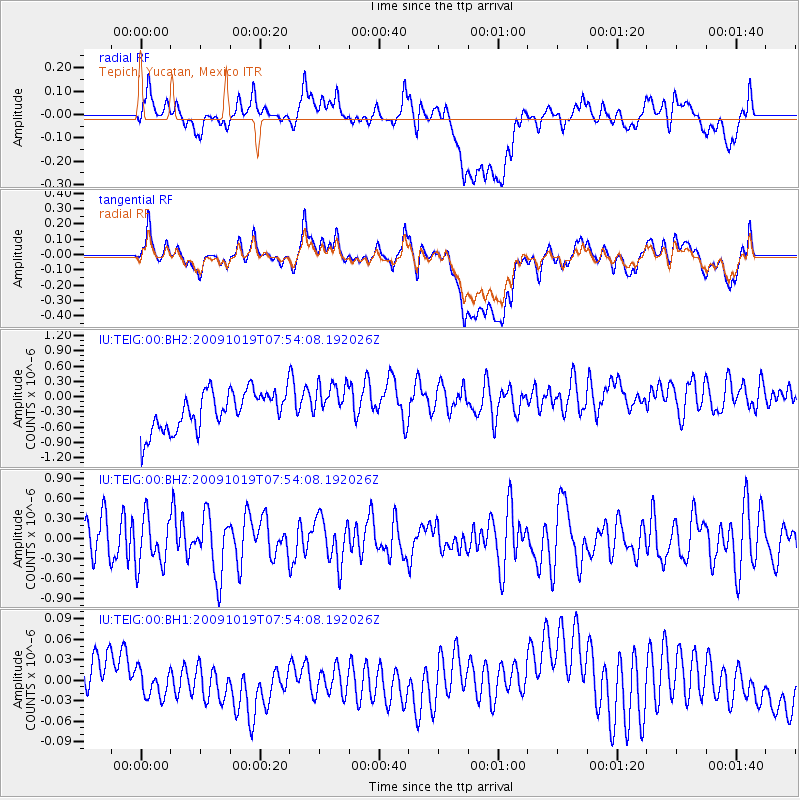
TEIG Tepich, Yucatan, Mexico - Earthquake Result Viewer
*The percent match for this event was below the threshold and hence no stack was calculated.
| Earthquake location: |
Samoa Islands Region |
| Earthquake latitude/longitude: |
-15.4/-173.0 |
| Earthquake time(UTC): |
2009/10/19 (292) 07:41:38 GMT |
| Earthquake Depth: |
10 km |
| Earthquake Magnitude: |
5.8 MW, 5.4 MS, 5.4 MB, 5.8 MW |
| Earthquake Catalog/Contributor: |
WHDF/NEIC |
|
| Network: |
IU Global Seismograph Network (GSN - IRIS/USGS) |
| Station: |
TEIG Tepich, Yucatan, Mexico |
| Lat/Lon: |
20.23 N/88.28 W |
| Elevation: |
40 m |
|
| Distance: |
90.4 deg |
| Az: |
69.243 deg |
| Baz: |
253.797 deg |
| Ray Param: |
$rayparam |
*The percent match for this event was below the threshold and hence was not used in the summary stack. |
|
| Radial Match: |
18.939602 % |
| Radial Bump: |
400 |
| Transverse Match: |
20.61206 % |
| Transverse Bump: |
400 |
| SOD ConfigId: |
617450 |
| Insert Time: |
2013-09-30 18:16:46.671 +0000 |
| GWidth: |
2.5 |
| Max Bumps: |
400 |
| Tol: |
0.001 |
|
Signal To Noise
| Channel | StoN | STA | LTA |
| IU:TEIG:00:BHZ:20091019T07:54:08.192026Z | 0.9128908 | 3.7406707E-7 | 4.0976101E-7 |
| IU:TEIG:00:BH1:20091019T07:54:08.192026Z | 0.6340096 | 2.0135019E-8 | 3.1758223E-8 |
| IU:TEIG:00:BH2:20091019T07:54:08.192026Z | 1.0245066 | 3.9297163E-7 | 3.8357157E-7 |
| Arrivals |
| Ps | |
| PpPs | |
| PsPs/PpSs | |


