You are here: Home > Network List > CB - China National Seismic Network Stations List
> Station WHN Wuhantai,Hubei Province > Earthquake Result Viewer
WHN Wuhantai,Hubei Province - Earthquake Result Viewer
| Earthquake location: |
New Ireland Region, P.N.G. |
| Earthquake latitude/longitude: |
-3.3/150.9 |
| Earthquake time(UTC): |
2014/10/19 (292) 19:38:38 GMT |
| Earthquake Depth: |
10 km |
| Earthquake Magnitude: |
5.9 MW |
| Earthquake Catalog/Contributor: |
ISC/ISC |
|
| Network: |
CB China National Seismic Network |
| Station: |
WHN Wuhantai,Hubei Province |
| Lat/Lon: |
30.54 N/114.35 E |
| Elevation: |
80 m |
|
| Distance: |
48.5 deg |
| Az: |
316.671 deg |
| Baz: |
127.436 deg |
| Ray Param: |
0.069307975 |
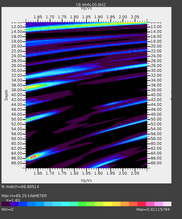
| Estimated Moho Depth: |
65.25 km |
| Estimated Crust Vp/Vs: |
1.63 |
| Assumed Crust Vp: |
6.276 km/s |
| Estimated Crust Vs: |
3.85 km/s |
| Estimated Crust Poisson's Ratio: |
0.20 |
|
| Radial Match: |
86.68514 % |
| Radial Bump: |
325 |
| Transverse Match: |
62.97926 % |
| Transverse Bump: |
400 |
| SOD ConfigId: |
3390531 |
| Insert Time: |
2019-04-14 15:18:21.363 +0000 |
| GWidth: |
2.5 |
| Max Bumps: |
400 |
| Tol: |
0.001 |
|

Signal To Noise
| Channel | StoN | STA | LTA |
| CB:WHN:00:BHZ:20141019T19:46:50.950007Z | 3.20218 | 2.9078225E-7 | 9.0807596E-8 |
| CB:WHN:00:BHN:20141019T19:46:50.950007Z | 1.0736574 | 1.294292E-7 | 1.205498E-7 |
| CB:WHN:00:BHE:20141019T19:46:50.950007Z | 1.2837982 | 1.285714E-7 | 1.0014923E-7 |
| Arrivals |
| Ps | 7.0 SECOND |
| PpPs | 26 SECOND |
| PsPs/PpSs | 33 SECOND |


