You are here: Home > Network List > CB - China National Seismic Network Stations List
> Station XLT Xilinhaote,Neimeng Province > Earthquake Result Viewer
XLT Xilinhaote,Neimeng Province - Earthquake Result Viewer
| Earthquake location: |
New Ireland Region, P.N.G. |
| Earthquake latitude/longitude: |
-3.3/150.9 |
| Earthquake time(UTC): |
2014/10/19 (292) 19:38:38 GMT |
| Earthquake Depth: |
10 km |
| Earthquake Magnitude: |
5.9 MW |
| Earthquake Catalog/Contributor: |
ISC/ISC |
|
| Network: |
CB China National Seismic Network |
| Station: |
XLT Xilinhaote,Neimeng Province |
| Lat/Lon: |
43.90 N/116.08 E |
| Elevation: |
1030 m |
|
| Distance: |
56.5 deg |
| Az: |
330.301 deg |
| Baz: |
136.825 deg |
| Ray Param: |
0.06411222 |
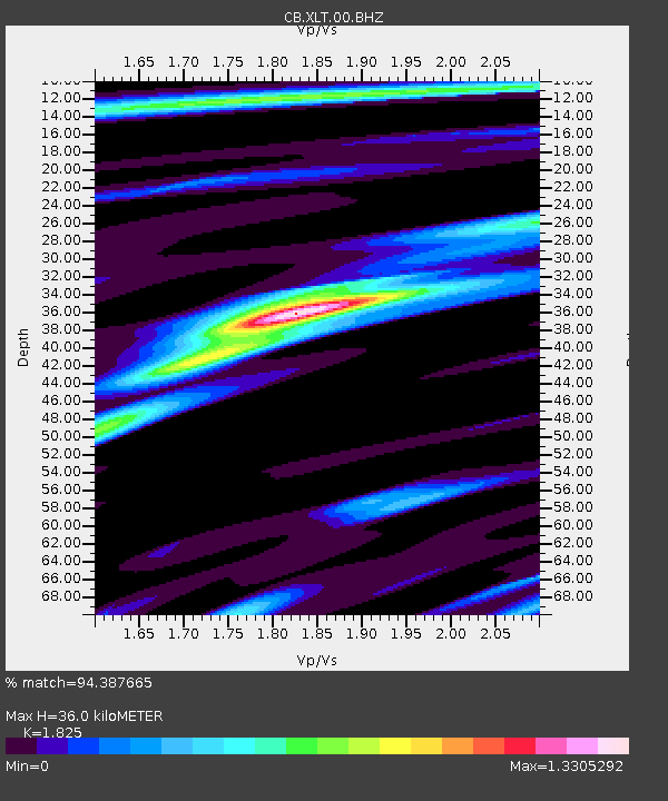
| Estimated Moho Depth: |
36.0 km |
| Estimated Crust Vp/Vs: |
1.83 |
| Assumed Crust Vp: |
6.459 km/s |
| Estimated Crust Vs: |
3.539 km/s |
| Estimated Crust Poisson's Ratio: |
0.29 |
|
| Radial Match: |
94.387665 % |
| Radial Bump: |
343 |
| Transverse Match: |
87.569595 % |
| Transverse Bump: |
341 |
| SOD ConfigId: |
3390531 |
| Insert Time: |
2019-04-14 15:18:22.163 +0000 |
| GWidth: |
2.5 |
| Max Bumps: |
400 |
| Tol: |
0.001 |
|

Signal To Noise
| Channel | StoN | STA | LTA |
| CB:XLT:00:BHZ:20141019T19:47:49.880Z | 4.2901044 | 2.8979974E-7 | 6.7550744E-8 |
| CB:XLT:00:BHN:20141019T19:47:49.880Z | 1.9335297 | 1.4130943E-7 | 7.308366E-8 |
| CB:XLT:00:BHE:20141019T19:47:49.880Z | 3.1738992 | 1.6466522E-7 | 5.1881052E-8 |
| Arrivals |
| Ps | 4.8 SECOND |
| PpPs | 15 SECOND |
| PsPs/PpSs | 20 SECOND |


