You are here: Home > Network List > II - Global Seismograph Network (GSN - IRIS/IDA) Stations List
> Station MSEY Mahe, Seychelles > Earthquake Result Viewer
MSEY Mahe, Seychelles - Earthquake Result Viewer
| Earthquake location: |
Banda Sea |
| Earthquake latitude/longitude: |
-6.1/130.4 |
| Earthquake time(UTC): |
2009/10/24 (297) 14:40:43 GMT |
| Earthquake Depth: |
130 km |
| Earthquake Magnitude: |
6.7 MB, 6.9 MW, 6.9 MW |
| Earthquake Catalog/Contributor: |
WHDF/NEIC |
|
| Network: |
II Global Seismograph Network (GSN - IRIS/IDA) |
| Station: |
MSEY Mahe, Seychelles |
| Lat/Lon: |
4.67 S/55.48 E |
| Elevation: |
475 m |
|
| Distance: |
74.5 deg |
| Az: |
266.851 deg |
| Baz: |
95.049 deg |
| Ray Param: |
0.051946882 |
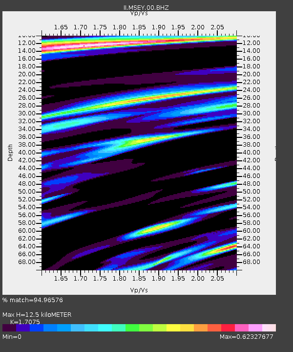
| Estimated Moho Depth: |
12.5 km |
| Estimated Crust Vp/Vs: |
1.71 |
| Assumed Crust Vp: |
6.303 km/s |
| Estimated Crust Vs: |
3.691 km/s |
| Estimated Crust Poisson's Ratio: |
0.24 |
|
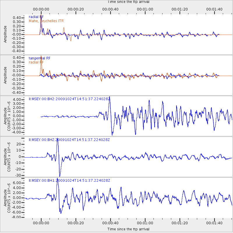
| Radial Match: |
94.96576 % |
| Radial Bump: |
352 |
| Transverse Match: |
85.440865 % |
| Transverse Bump: |
393 |
| SOD ConfigId: |
617450 |
| Insert Time: |
2013-09-30 18:25:50.349 +0000 |
| GWidth: |
2.5 |
| Max Bumps: |
400 |
| Tol: |
0.001 |
|
Signal To Noise
| Channel | StoN | STA | LTA |
| II:MSEY:00:BHZ:20091024T14:51:37.224028Z | 16.893583 | 2.7454905E-6 | 1.6251677E-7 |
| II:MSEY:00:BH1:20091024T14:51:37.224028Z | 7.0606666 | 8.0908393E-7 | 1.145903E-7 |
| II:MSEY:00:BH2:20091024T14:51:37.224028Z | 4.6249437 | 4.5923937E-7 | 9.929621E-8 |
| Arrivals |
| Ps | 1.4 SECOND |
| PpPs | 5.2 SECOND |
| PsPs/PpSs | 6.6 SECOND |


