You are here: Home > Network List > JP - Japan Meteorological Agency Seismic Network Stations List
> Station JHS Hiroshima Saijyo > Earthquake Result Viewer
JHS Hiroshima Saijyo - Earthquake Result Viewer
| Earthquake location: |
New Ireland Region, P.N.G. |
| Earthquake latitude/longitude: |
-3.3/150.9 |
| Earthquake time(UTC): |
2014/10/19 (292) 19:38:38 GMT |
| Earthquake Depth: |
10 km |
| Earthquake Magnitude: |
5.9 MW |
| Earthquake Catalog/Contributor: |
ISC/ISC |
|
| Network: |
JP Japan Meteorological Agency Seismic Network |
| Station: |
JHS Hiroshima Saijyo |
| Lat/Lon: |
35.00 N/133.11 E |
| Elevation: |
470 m |
|
| Distance: |
41.7 deg |
| Az: |
337.797 deg |
| Baz: |
152.643 deg |
| Ray Param: |
0.073655225 |
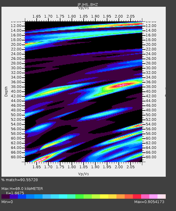
| Estimated Moho Depth: |
69.0 km |
| Estimated Crust Vp/Vs: |
1.67 |
| Assumed Crust Vp: |
6.468 km/s |
| Estimated Crust Vs: |
3.879 km/s |
| Estimated Crust Poisson's Ratio: |
0.22 |
|
| Radial Match: |
90.55728 % |
| Radial Bump: |
400 |
| Transverse Match: |
74.353874 % |
| Transverse Bump: |
400 |
| SOD ConfigId: |
3390531 |
| Insert Time: |
2019-04-14 15:19:59.624 +0000 |
| GWidth: |
2.5 |
| Max Bumps: |
400 |
| Tol: |
0.001 |
|

Signal To Noise
| Channel | StoN | STA | LTA |
| JP:JHS: :BHZ:20141019T19:45:56.499995Z | 3.1953351 | 4.060089E-7 | 1.27063E-7 |
| JP:JHS: :BHN:20141019T19:45:56.499995Z | 1.281934 | 1.3661871E-7 | 1.06572344E-7 |
| JP:JHS: :BHE:20141019T19:45:56.499995Z | 1.2427269 | 1.2430502E-7 | 1.0002601E-7 |
| Arrivals |
| Ps | 7.7 SECOND |
| PpPs | 26 SECOND |
| PsPs/PpSs | 34 SECOND |


