You are here: Home > Network List > IU - Global Seismograph Network (GSN - IRIS/USGS) Stations List
> Station RSSD Black Hills, South Dakota, USA > Earthquake Result Viewer
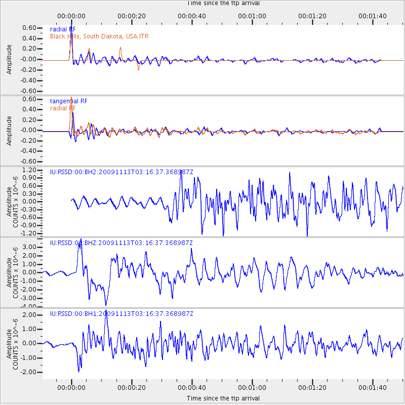
RSSD Black Hills, South Dakota, USA - Earthquake Result Viewer
*The percent match for this event was below the threshold and hence no stack was calculated.
| Earthquake location: |
Near Coast Of Northern Chile |
| Earthquake latitude/longitude: |
-19.4/-70.3 |
| Earthquake time(UTC): |
2009/11/13 (317) 03:05:57 GMT |
| Earthquake Depth: |
27 km |
| Earthquake Magnitude: |
6.2 MB, 6.4 MS, 6.5 MW, 6.5 MW |
| Earthquake Catalog/Contributor: |
WHDF/NEIC |
|
| Network: |
IU Global Seismograph Network (GSN - IRIS/USGS) |
| Station: |
RSSD Black Hills, South Dakota, USA |
| Lat/Lon: |
44.12 N/104.04 W |
| Elevation: |
2090 m |
|
| Distance: |
70.3 deg |
| Az: |
334.88 deg |
| Baz: |
146.193 deg |
| Ray Param: |
$rayparam |
*The percent match for this event was below the threshold and hence was not used in the summary stack. |
|
| Radial Match: |
92.27176 % |
| Radial Bump: |
400 |
| Transverse Match: |
81.31927 % |
| Transverse Bump: |
400 |
| SOD ConfigId: |
617450 |
| Insert Time: |
2013-09-30 19:23:50.318 +0000 |
| GWidth: |
2.5 |
| Max Bumps: |
400 |
| Tol: |
0.001 |
|
Signal To Noise
| Channel | StoN | STA | LTA |
| IU:RSSD:00:BHZ:20091113T03:16:37.368987Z | 13.250082 | 1.7187629E-6 | 1.2971715E-7 |
| IU:RSSD:00:BH1:20091113T03:16:37.368987Z | 6.5116925 | 7.641222E-7 | 1.17346175E-7 |
| IU:RSSD:00:BH2:20091113T03:16:37.368987Z | 2.8973725 | 3.481351E-7 | 1.2015545E-7 |
| Arrivals |
| Ps | |
| PpPs | |
| PsPs/PpSs | |


