You are here: Home > Network List > IU - Global Seismograph Network (GSN - IRIS/USGS) Stations List
> Station TEIG Tepich, Yucatan, Mexico > Earthquake Result Viewer
TEIG Tepich, Yucatan, Mexico - Earthquake Result Viewer

| Earthquake location: |
Near Coast Of Northern Chile |
| Earthquake latitude/longitude: |
-19.4/-70.3 |
| Earthquake time(UTC): |
2009/11/13 (317) 03:05:57 GMT |
| Earthquake Depth: |
27 km |
| Earthquake Magnitude: |
6.2 MB, 6.4 MS, 6.5 MW, 6.5 MW |
| Earthquake Catalog/Contributor: |
WHDF/NEIC |
|
| Network: |
IU Global Seismograph Network (GSN - IRIS/USGS) |
| Station: |
TEIG Tepich, Yucatan, Mexico |
| Lat/Lon: |
20.23 N/88.28 W |
| Elevation: |
40 m |
|
| Distance: |
43.1 deg |
| Az: |
334.946 deg |
| Baz: |
154.807 deg |
| Ray Param: |
0.07270303 |
| Estimated Moho Depth: |
44.0 km |
| Estimated Crust Vp/Vs: |
1.99 |
| Assumed Crust Vp: |
5.817 km/s |
| Estimated Crust Vs: |
2.927 km/s |
| Estimated Crust Poisson's Ratio: |
0.33 |
|
| Radial Match: |
91.79489 % |
| Radial Bump: |
362 |
| Transverse Match: |
91.396515 % |
| Transverse Bump: |
358 |
| SOD ConfigId: |
617450 |
| Insert Time: |
2013-09-30 19:23:54.003 +0000 |
| GWidth: |
2.5 |
| Max Bumps: |
400 |
| Tol: |
0.001 |
|
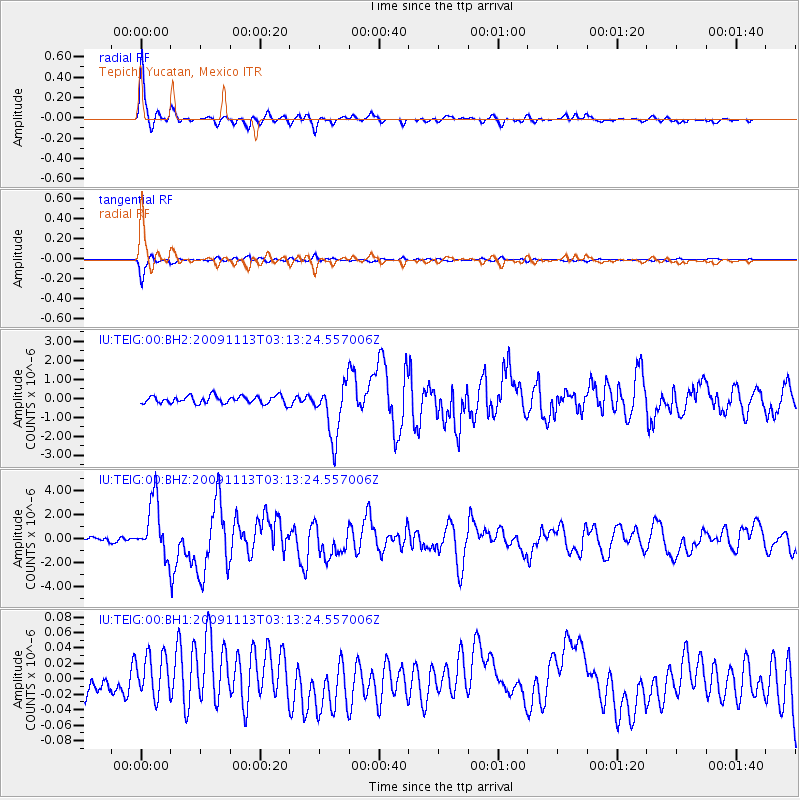
Signal To Noise
| Channel | StoN | STA | LTA |
| IU:TEIG:00:BHZ:20091113T03:13:24.557006Z | 10.618614 | 2.3459222E-6 | 2.2092546E-7 |
| IU:TEIG:00:BH1:20091113T03:13:24.557006Z | 3.1823583 | 3.0578946E-8 | 9.608895E-9 |
| IU:TEIG:00:BH2:20091113T03:13:24.557006Z | 7.194997 | 1.4336416E-6 | 1.9925535E-7 |
| Arrivals |
| Ps | 7.8 SECOND |
| PpPs | 22 SECOND |
| PsPs/PpSs | 29 SECOND |


