You are here: Home > Network List > IU - Global Seismograph Network (GSN - IRIS/USGS) Stations List
> Station RSSD Black Hills, South Dakota, USA > Earthquake Result Viewer
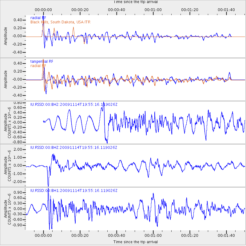
RSSD Black Hills, South Dakota, USA - Earthquake Result Viewer
*The percent match for this event was below the threshold and hence no stack was calculated.
| Earthquake location: |
Jujuy Province, Argentina |
| Earthquake latitude/longitude: |
-23.0/-66.6 |
| Earthquake time(UTC): |
2009/11/14 (318) 19:44:29 GMT |
| Earthquake Depth: |
220 km |
| Earthquake Magnitude: |
5.8 MB, 6.2 MW, 6.1 MW |
| Earthquake Catalog/Contributor: |
WHDF/NEIC |
|
| Network: |
IU Global Seismograph Network (GSN - IRIS/USGS) |
| Station: |
RSSD Black Hills, South Dakota, USA |
| Lat/Lon: |
44.12 N/104.04 W |
| Elevation: |
2090 m |
|
| Distance: |
75.0 deg |
| Az: |
333.081 deg |
| Baz: |
144.592 deg |
| Ray Param: |
$rayparam |
*The percent match for this event was below the threshold and hence was not used in the summary stack. |
|
| Radial Match: |
57.35201 % |
| Radial Bump: |
400 |
| Transverse Match: |
65.4052 % |
| Transverse Bump: |
400 |
| SOD ConfigId: |
617450 |
| Insert Time: |
2013-09-30 19:30:20.691 +0000 |
| GWidth: |
2.5 |
| Max Bumps: |
400 |
| Tol: |
0.001 |
|
Signal To Noise
| Channel | StoN | STA | LTA |
| IU:RSSD:00:BHZ:20091114T19:55:16.119026Z | 7.6502185 | 8.9305246E-7 | 1.1673555E-7 |
| IU:RSSD:00:BH1:20091114T19:55:16.119026Z | 3.2676463 | 5.6910534E-7 | 1.7416369E-7 |
| IU:RSSD:00:BH2:20091114T19:55:16.119026Z | 2.1335511 | 5.1013427E-7 | 2.3910104E-7 |
| Arrivals |
| Ps | |
| PpPs | |
| PsPs/PpSs | |


