You are here: Home > Network List > IU - Global Seismograph Network (GSN - IRIS/USGS) Stations List
> Station TEIG Tepich, Yucatan, Mexico > Earthquake Result Viewer
TEIG Tepich, Yucatan, Mexico - Earthquake Result Viewer

| Earthquake location: |
Jujuy Province, Argentina |
| Earthquake latitude/longitude: |
-23.0/-66.6 |
| Earthquake time(UTC): |
2009/11/14 (318) 19:44:29 GMT |
| Earthquake Depth: |
220 km |
| Earthquake Magnitude: |
5.8 MB, 6.2 MW, 6.1 MW |
| Earthquake Catalog/Contributor: |
WHDF/NEIC |
|
| Network: |
IU Global Seismograph Network (GSN - IRIS/USGS) |
| Station: |
TEIG Tepich, Yucatan, Mexico |
| Lat/Lon: |
20.23 N/88.28 W |
| Elevation: |
40 m |
|
| Distance: |
47.8 deg |
| Az: |
332.154 deg |
| Baz: |
152.714 deg |
| Ray Param: |
0.06889862 |
| Estimated Moho Depth: |
27.5 km |
| Estimated Crust Vp/Vs: |
2.10 |
| Assumed Crust Vp: |
5.817 km/s |
| Estimated Crust Vs: |
2.777 km/s |
| Estimated Crust Poisson's Ratio: |
0.35 |
|
| Radial Match: |
81.04097 % |
| Radial Bump: |
400 |
| Transverse Match: |
66.9694 % |
| Transverse Bump: |
400 |
| SOD ConfigId: |
617450 |
| Insert Time: |
2013-09-30 19:30:25.480 +0000 |
| GWidth: |
2.5 |
| Max Bumps: |
400 |
| Tol: |
0.001 |
|
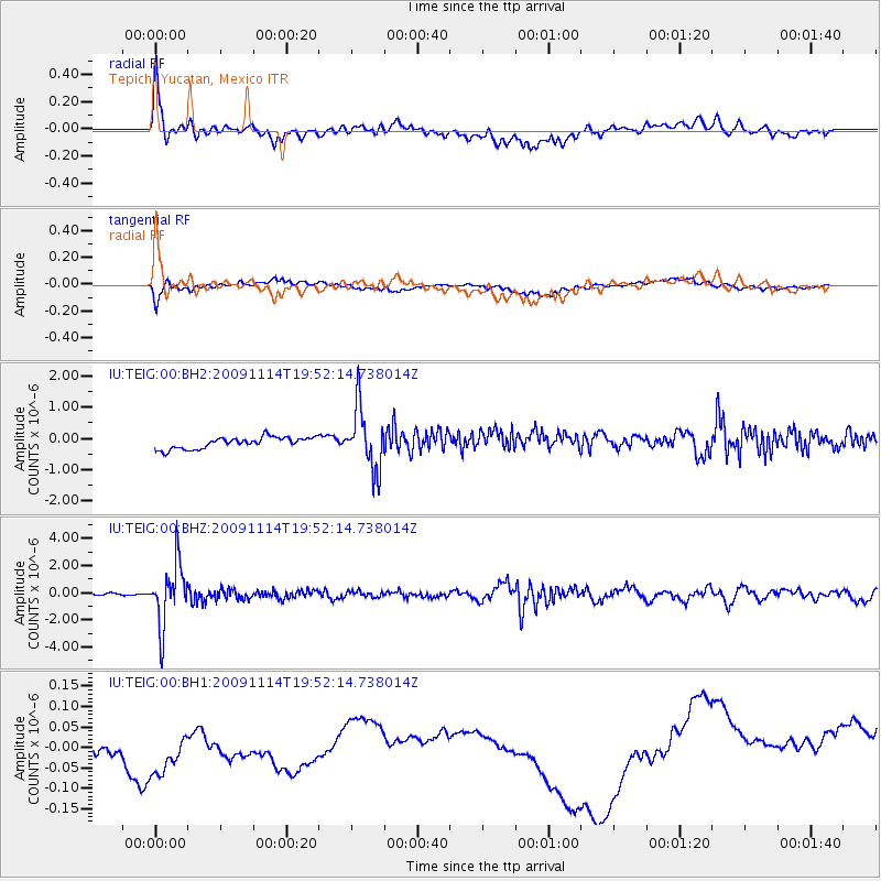
Signal To Noise
| Channel | StoN | STA | LTA |
| IU:TEIG:00:BHZ:20091114T19:52:14.738014Z | 25.777155 | 2.2197821E-6 | 8.611432E-8 |
| IU:TEIG:00:BH1:20091114T19:52:14.738014Z | 0.9606327 | 1.4066113E-7 | 1.464255E-7 |
| IU:TEIG:00:BH2:20091114T19:52:14.738014Z | 5.4062343 | 9.860267E-7 | 1.8238697E-7 |
| Arrivals |
| Ps | 5.4 SECOND |
| PpPs | 14 SECOND |
| PsPs/PpSs | 19 SECOND |


