You are here: Home > Network List > CI - Caltech Regional Seismic Network Stations List
> Station TIN Tinemaha, California, USA > Earthquake Result Viewer
TIN Tinemaha, California, USA - Earthquake Result Viewer
| Earthquake location: |
Dominican Republic Region |
| Earthquake latitude/longitude: |
19.8/-70.7 |
| Earthquake time(UTC): |
2003/09/22 (265) 04:45:36 GMT |
| Earthquake Depth: |
10 km |
| Earthquake Magnitude: |
6.2 MB, 6.6 MS, 6.5 MW, 6.4 MW |
| Earthquake Catalog/Contributor: |
WHDF/NEIC |
|
| Network: |
CI Caltech Regional Seismic Network |
| Station: |
TIN Tinemaha, California, USA |
| Lat/Lon: |
37.05 N/118.23 W |
| Elevation: |
1164 m |
|
| Distance: |
44.7 deg |
| Az: |
303.004 deg |
| Baz: |
99.174 deg |
| Ray Param: |
0.07172729 |
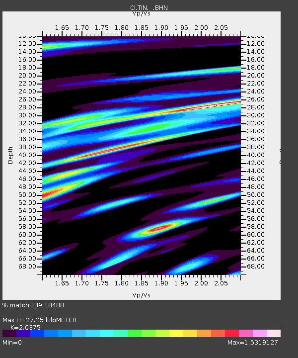
| Estimated Moho Depth: |
27.25 km |
| Estimated Crust Vp/Vs: |
2.04 |
| Assumed Crust Vp: |
6.291 km/s |
| Estimated Crust Vs: |
3.088 km/s |
| Estimated Crust Poisson's Ratio: |
0.34 |
|
| Radial Match: |
89.18488 % |
| Radial Bump: |
400 |
| Transverse Match: |
82.65305 % |
| Transverse Bump: |
400 |
| SOD ConfigId: |
3787 |
| Insert Time: |
2010-02-25 20:47:28.370 +0000 |
| GWidth: |
2.5 |
| Max Bumps: |
400 |
| Tol: |
0.001 |
|

Signal To Noise
| Channel | StoN | STA | LTA |
| CI:TIN: :BHN:20030922T04:53:18.802988Z | 1.3957592 | 1.9396832E-7 | 1.3896975E-7 |
| CI:TIN: :BHE:20030922T04:53:18.802988Z | 1.0739594 | 1.5341496E-7 | 1.4284987E-7 |
| CI:TIN: :BHZ:20030922T04:53:18.802988Z | 3.0060859 | 3.9316532E-7 | 1.3078979E-7 |
| Arrivals |
| Ps | 4.7 SECOND |
| PpPs | 12 SECOND |
| PsPs/PpSs | 17 SECOND |


