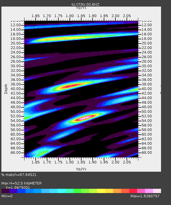
OTAV Otavalo, Ecuador - Earthquake Result Viewer
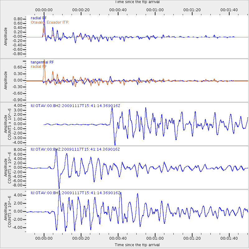
Earthquake location: Queen Charlotte Islands Region
Earthquake latitude/longitude: 52.1/-131.4
Earthquake time(UTC): 2009/11/17 (321) 15:30:47 GMT
Earthquake Depth: 17 km
Earthquake Magnitude: 6.6 MW, 6.0 MB, 6.5 MS, 6.6 MW
Earthquake Catalog/Contributor: NEIC PDE/NEIC PDE-M
Network: IU Global Seismograph Network (GSN - IRIS/USGS)
Station: OTAV Otavalo, Ecuador
Lat/Lon: 0.24 N/78.45 W
Elevation: 3510 m
Distance: 68.0 deg
Az: 120.596 deg
Baz: 327.947 deg
Ray Param: 0.05658197
Estimated Moho Depth: 52.5 km
Estimated Crust Vp/Vs: 1.87
Assumed Crust Vp: 6.472 km/s
Estimated Crust Vs: 3.466 km/s
Estimated Crust Poisson's Ratio: 0.30
Radial Match: 97.94521 %
Radial Bump: 360
Transverse Match: 91.85046 %
Transverse Bump: 400
SOD ConfigId: 617450
Insert Time: 2013-09-30 19:33:10.751 +0000
GWidth: 2.5
Max Bumps: 400
Tol: 0.001

Signal To Noise

ChannelStoNSTALTA
IU:OTAV:00:BHZ:20091117T15:41:14.369016Z3.375472.620734E-77.7640564E-8
IU:OTAV:00:BH1:20091117T15:41:14.369016Z2.8497221.5487393E-75.4347034E-8
IU:OTAV:00:BH2:20091117T15:41:14.369016Z1.35327488.711931E-86.437666E-8
Arrivals
Ps7.3 SECOND
PpPs22 SECOND
PsPs/PpSs30 SECOND