You are here: Home > Network List > IU - Global Seismograph Network (GSN - IRIS/USGS) Stations List
> Station TEIG Tepich, Yucatan, Mexico > Earthquake Result Viewer
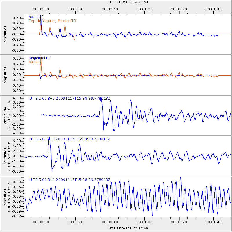
TEIG Tepich, Yucatan, Mexico - Earthquake Result Viewer

| Earthquake location: |
Queen Charlotte Islands Region |
| Earthquake latitude/longitude: |
52.1/-131.4 |
| Earthquake time(UTC): |
2009/11/17 (321) 15:30:47 GMT |
| Earthquake Depth: |
17 km |
| Earthquake Magnitude: |
6.6 MW, 6.0 MB, 6.5 MS, 6.6 MW |
| Earthquake Catalog/Contributor: |
NEIC PDE/NEIC PDE-M |
|
| Network: |
IU Global Seismograph Network (GSN - IRIS/USGS) |
| Station: |
TEIG Tepich, Yucatan, Mexico |
| Lat/Lon: |
20.23 N/88.28 W |
| Elevation: |
40 m |
|
| Distance: |
46.1 deg |
| Az: |
117.053 deg |
| Baz: |
324.218 deg |
| Ray Param: |
0.07082682 |
| Estimated Moho Depth: |
69.0 km |
| Estimated Crust Vp/Vs: |
1.89 |
| Assumed Crust Vp: |
5.817 km/s |
| Estimated Crust Vs: |
3.078 km/s |
| Estimated Crust Poisson's Ratio: |
0.31 |
|
| Radial Match: |
91.14372 % |
| Radial Bump: |
391 |
| Transverse Match: |
86.24717 % |
| Transverse Bump: |
400 |
| SOD ConfigId: |
617450 |
| Insert Time: |
2013-09-30 19:33:18.387 +0000 |
| GWidth: |
2.5 |
| Max Bumps: |
400 |
| Tol: |
0.001 |
|
Signal To Noise
| Channel | StoN | STA | LTA |
| IU:TEIG:00:BHZ:20091117T15:38:39.778013Z | 22.005138 | 2.2945396E-6 | 1.042729E-7 |
| IU:TEIG:00:BH1:20091117T15:38:39.778013Z | 0.2846759 | 2.129661E-8 | 7.4810025E-8 |
| IU:TEIG:00:BH2:20091117T15:38:39.778013Z | 9.68575 | 1.2577855E-6 | 1.2985939E-7 |
| Arrivals |
| Ps | 11 SECOND |
| PpPs | 33 SECOND |
| PsPs/PpSs | 44 SECOND |


