You are here: Home > Network List > GM - US Geological Survey Networks Stations List
> Station IWM01 Jericho 2M Well Monitoring Station > Earthquake Result Viewer
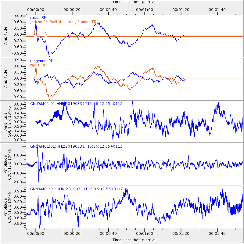
IWM01 Jericho 2M Well Monitoring Station - Earthquake Result Viewer
*The percent match for this event was below the threshold and hence no stack was calculated.
| Earthquake location: |
Off Coast Of Northern Peru |
| Earthquake latitude/longitude: |
-10.0/-79.3 |
| Earthquake time(UTC): |
2019/03/31 (090) 15:27:57 GMT |
| Earthquake Depth: |
29 km |
| Earthquake Magnitude: |
5.5 Mww |
| Earthquake Catalog/Contributor: |
NEIC PDE/us |
|
| Network: |
GM US Geological Survey Networks |
| Station: |
IWM01 Jericho 2M Well Monitoring Station |
| Lat/Lon: |
36.73 N/96.53 W |
| Elevation: |
328 m |
|
| Distance: |
49.2 deg |
| Az: |
341.695 deg |
| Baz: |
157.35 deg |
| Ray Param: |
$rayparam |
*The percent match for this event was below the threshold and hence was not used in the summary stack. |
|
| Radial Match: |
36.070793 % |
| Radial Bump: |
400 |
| Transverse Match: |
27.160309 % |
| Transverse Bump: |
400 |
| SOD ConfigId: |
3426611 |
| Insert Time: |
2019-04-14 15:31:34.710 +0000 |
| GWidth: |
2.5 |
| Max Bumps: |
400 |
| Tol: |
0.001 |
|
Signal To Noise
| Channel | StoN | STA | LTA |
| GM:IWM01:01:HHZ:20190331T15:36:12.554011Z | 8.047041 | 8.985039E-7 | 1.1165644E-7 |
| GM:IWM01:01:HHN:20190331T15:36:12.554011Z | 1.2013334 | 6.879251E-7 | 5.7263463E-7 |
| GM:IWM01:01:HHE:20190331T15:36:12.554011Z | 1.632475 | 3.986918E-7 | 2.4422536E-7 |
| Arrivals |
| Ps | |
| PpPs | |
| PsPs/PpSs | |


