You are here: Home > Network List > GS - US Geological Survey Networks Stations List
> Station KAN10 Keim Farm > Earthquake Result Viewer
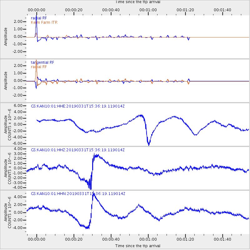
KAN10 Keim Farm - Earthquake Result Viewer
*The percent match for this event was below the threshold and hence no stack was calculated.
| Earthquake location: |
Off Coast Of Northern Peru |
| Earthquake latitude/longitude: |
-10.0/-79.3 |
| Earthquake time(UTC): |
2019/03/31 (090) 15:27:57 GMT |
| Earthquake Depth: |
29 km |
| Earthquake Magnitude: |
5.5 Mww |
| Earthquake Catalog/Contributor: |
NEIC PDE/us |
|
| Network: |
GS US Geological Survey Networks |
| Station: |
KAN10 Keim Farm |
| Lat/Lon: |
37.12 N/98.10 W |
| Elevation: |
417 m |
|
| Distance: |
50.0 deg |
| Az: |
340.395 deg |
| Baz: |
155.572 deg |
| Ray Param: |
$rayparam |
*The percent match for this event was below the threshold and hence was not used in the summary stack. |
|
| Radial Match: |
61.276264 % |
| Radial Bump: |
268 |
| Transverse Match: |
48.832745 % |
| Transverse Bump: |
365 |
| SOD ConfigId: |
3426611 |
| Insert Time: |
2019-04-14 15:31:59.943 +0000 |
| GWidth: |
2.5 |
| Max Bumps: |
400 |
| Tol: |
0.001 |
|
Signal To Noise
| Channel | StoN | STA | LTA |
| GS:KAN10:01:HHZ:20190331T15:36:19.119014Z | 0.7780141 | 4.820045E-7 | 6.195318E-7 |
| GS:KAN10:01:HHN:20190331T15:36:19.119014Z | 4.4429994 | 1.9782672E-6 | 4.4525487E-7 |
| GS:KAN10:01:HHE:20190331T15:36:19.119014Z | 3.3969142 | 3.0183146E-6 | 8.885461E-7 |
| Arrivals |
| Ps | |
| PpPs | |
| PsPs/PpSs | |


