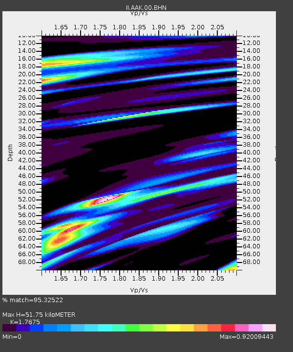
AAK Ala Archa, Kyrgyzstan - Earthquake Result Viewer

Earthquake location: Off W Coast Of Northern Sumatra
Earthquake latitude/longitude: 2.9/95.6
Earthquake time(UTC): 2005/02/26 (057) 12:56:52 GMT
Earthquake Depth: 36 km
Earthquake Magnitude: 6.0 MB, 6.7 MS, 6.8 MW, 6.7 MW
Earthquake Catalog/Contributor: WHDF/NEIC
Network: II Global Seismograph Network (GSN - IRIS/IDA)
Station: AAK Ala Archa, Kyrgyzstan
Lat/Lon: 42.64 N/74.49 E
Elevation: 1645 m
Distance: 43.8 deg
Az: 337.44 deg
Baz: 148.717 deg
Ray Param: 0.07222766
Estimated Moho Depth: 51.75 km
Estimated Crust Vp/Vs: 1.77
Assumed Crust Vp: 6.306 km/s
Estimated Crust Vs: 3.568 km/s
Estimated Crust Poisson's Ratio: 0.26
Radial Match: 95.32522 %
Radial Bump: 400
Transverse Match: 90.80082 %
Transverse Bump: 400
SOD ConfigId: 2455
Insert Time: 2010-03-01 15:28:32.136 +0000
GWidth: 2.5
Max Bumps: 400
Tol: 0.001

Signal To Noise

ChannelStoNSTALTA
II:AAK:00:BHN:20050226T13:04:24.591008Z5.16073237.667066E-71.4856548E-7
II:AAK:00:BHE:20050226T13:04:24.591008Z4.6151966.9136235E-71.498013E-7
II:AAK:00:BHZ:20050226T13:04:24.591008Z10.9833541.9017046E-61.7314426E-7
Arrivals
Ps6.7 SECOND
PpPs21 SECOND
PsPs/PpSs28 SECOND