You are here: Home > Network List > IU - Global Seismograph Network (GSN - IRIS/USGS) Stations List
> Station PMG Port Moresby, New Guinea > Earthquake Result Viewer
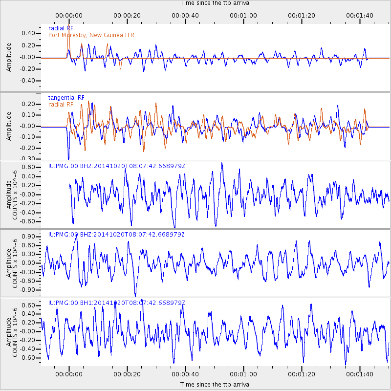
PMG Port Moresby, New Guinea - Earthquake Result Viewer
*The percent match for this event was below the threshold and hence no stack was calculated.
| Earthquake location: |
Balleny Islands Region |
| Earthquake latitude/longitude: |
-62.0/161.3 |
| Earthquake time(UTC): |
2014/10/20 (293) 07:58:53 GMT |
| Earthquake Depth: |
10 km |
| Earthquake Magnitude: |
5.7 MW |
| Earthquake Catalog/Contributor: |
ISC/ISC |
|
| Network: |
IU Global Seismograph Network (GSN - IRIS/USGS) |
| Station: |
PMG Port Moresby, New Guinea |
| Lat/Lon: |
9.40 S/147.16 E |
| Elevation: |
90 m |
|
| Distance: |
53.5 deg |
| Az: |
342.573 deg |
| Baz: |
171.765 deg |
| Ray Param: |
$rayparam |
*The percent match for this event was below the threshold and hence was not used in the summary stack. |
|
| Radial Match: |
54.162373 % |
| Radial Bump: |
400 |
| Transverse Match: |
58.88576 % |
| Transverse Bump: |
400 |
| SOD ConfigId: |
3390531 |
| Insert Time: |
2019-04-14 15:32:31.941 +0000 |
| GWidth: |
2.5 |
| Max Bumps: |
400 |
| Tol: |
0.001 |
|
Signal To Noise
| Channel | StoN | STA | LTA |
| IU:PMG:00:BHZ:20141020T08:07:42.668979Z | 1.7526928 | 5.5398704E-7 | 3.1607763E-7 |
| IU:PMG:00:BH1:20141020T08:07:42.668979Z | 0.8937358 | 2.3757309E-7 | 2.6582026E-7 |
| IU:PMG:00:BH2:20141020T08:07:42.668979Z | 0.7211662 | 1.7703103E-7 | 2.4547882E-7 |
| Arrivals |
| Ps | |
| PpPs | |
| PsPs/PpSs | |


