You are here: Home > Network List > YT07 - POLENET Stations List
> Station UNGL UNGL > Earthquake Result Viewer
UNGL UNGL - Earthquake Result Viewer
| Earthquake location: |
Balleny Islands Region |
| Earthquake latitude/longitude: |
-62.0/161.3 |
| Earthquake time(UTC): |
2014/10/20 (293) 07:58:53 GMT |
| Earthquake Depth: |
10 km |
| Earthquake Magnitude: |
5.7 MW |
| Earthquake Catalog/Contributor: |
ISC/ISC |
|
| Network: |
YT POLENET |
| Station: |
UNGL UNGL |
| Lat/Lon: |
79.77 S/82.52 W |
| Elevation: |
745 m |
|
| Distance: |
33.9 deg |
| Az: |
163.283 deg |
| Baz: |
229.436 deg |
| Ray Param: |
0.07800577 |
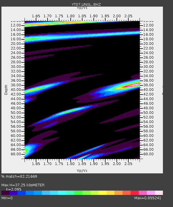
| Estimated Moho Depth: |
37.25 km |
| Estimated Crust Vp/Vs: |
2.10 |
| Assumed Crust Vp: |
6.182 km/s |
| Estimated Crust Vs: |
2.951 km/s |
| Estimated Crust Poisson's Ratio: |
0.35 |
|
| Radial Match: |
82.21669 % |
| Radial Bump: |
369 |
| Transverse Match: |
75.61406 % |
| Transverse Bump: |
400 |
| SOD ConfigId: |
3390531 |
| Insert Time: |
2019-04-14 15:33:15.245 +0000 |
| GWidth: |
2.5 |
| Max Bumps: |
400 |
| Tol: |
0.001 |
|

Signal To Noise
| Channel | StoN | STA | LTA |
| YT:UNGL: :BHZ:20141020T08:05:05.074985Z | 1.7182136 | 1.7290807E-7 | 1.0063247E-7 |
| YT:UNGL: :BHN:20141020T08:05:05.074985Z | 2.9690204 | 1.6233828E-7 | 5.467739E-8 |
| YT:UNGL: :BHE:20141020T08:05:05.074985Z | 1.7399127 | 1.4221E-7 | 8.173399E-8 |
| Arrivals |
| Ps | 7.0 SECOND |
| PpPs | 18 SECOND |
| PsPs/PpSs | 25 SECOND |


