You are here: Home > Network List > YT07 - POLENET Stations List
> Station WAWA WAWA > Earthquake Result Viewer
WAWA WAWA - Earthquake Result Viewer
| Earthquake location: |
Balleny Islands Region |
| Earthquake latitude/longitude: |
-62.0/161.3 |
| Earthquake time(UTC): |
2014/10/20 (293) 07:58:53 GMT |
| Earthquake Depth: |
10 km |
| Earthquake Magnitude: |
5.7 MW |
| Earthquake Catalog/Contributor: |
ISC/ISC |
|
| Network: |
YT POLENET |
| Station: |
WAWA WAWA |
| Lat/Lon: |
81.58 S/28.42 W |
| Elevation: |
1202 m |
|
| Distance: |
36.5 deg |
| Az: |
177.608 deg |
| Baz: |
187.678 deg |
| Ray Param: |
0.07662514 |
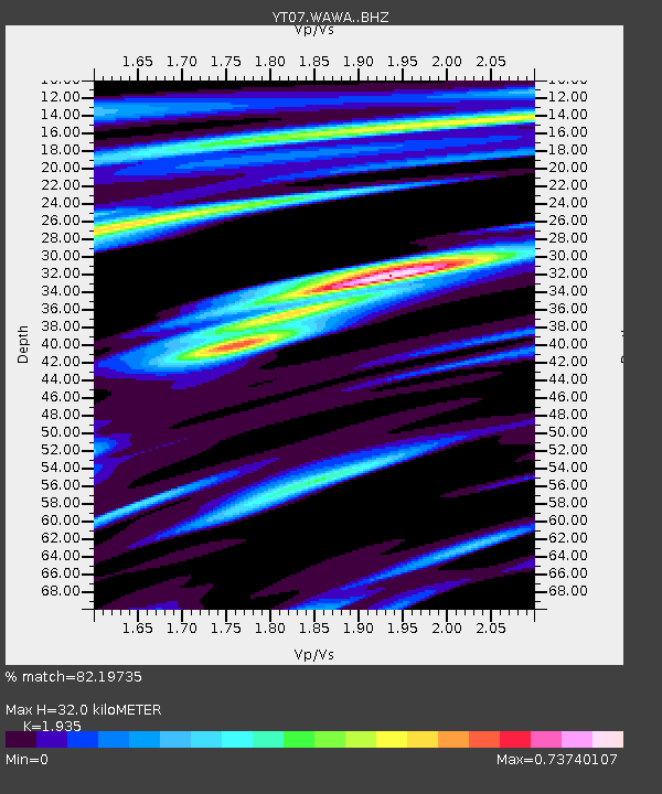
| Estimated Moho Depth: |
32.0 km |
| Estimated Crust Vp/Vs: |
1.93 |
| Assumed Crust Vp: |
6.424 km/s |
| Estimated Crust Vs: |
3.32 km/s |
| Estimated Crust Poisson's Ratio: |
0.32 |
|
| Radial Match: |
82.19735 % |
| Radial Bump: |
324 |
| Transverse Match: |
80.813446 % |
| Transverse Bump: |
400 |
| SOD ConfigId: |
3390531 |
| Insert Time: |
2019-04-14 15:33:16.078 +0000 |
| GWidth: |
2.5 |
| Max Bumps: |
400 |
| Tol: |
0.001 |
|

Signal To Noise
| Channel | StoN | STA | LTA |
| YT:WAWA: :BHZ:20141020T08:05:27.97501Z | 2.2805035 | 3.0958168E-7 | 1.3575146E-7 |
| YT:WAWA: :BHN:20141020T08:05:27.97501Z | 3.7237325 | 1.6244962E-7 | 4.3625484E-8 |
| YT:WAWA: :BHE:20141020T08:05:27.97501Z | 1.4897567 | 9.4611806E-8 | 6.3508224E-8 |
| Arrivals |
| Ps | 5.0 SECOND |
| PpPs | 14 SECOND |
| PsPs/PpSs | 19 SECOND |


