You are here: Home > Network List > II - Global Seismograph Network (GSN - IRIS/IDA) Stations List
> Station MSEY Mahe, Seychelles > Earthquake Result Viewer
MSEY Mahe, Seychelles - Earthquake Result Viewer
*The percent match for this event was below the threshold and hence no stack was calculated.
| Earthquake location: |
West Of Gibraltar |
| Earthquake latitude/longitude: |
36.5/-9.9 |
| Earthquake time(UTC): |
2009/12/17 (351) 01:37:48 GMT |
| Earthquake Depth: |
20 km |
| Earthquake Magnitude: |
5.6 MW, 5.5 MW, 5.7 MB |
| Earthquake Catalog/Contributor: |
NEIC PDE/NEIC PDE-M |
|
| Network: |
II Global Seismograph Network (GSN - IRIS/IDA) |
| Station: |
MSEY Mahe, Seychelles |
| Lat/Lon: |
4.67 S/55.48 E |
| Elevation: |
475 m |
|
| Distance: |
73.3 deg |
| Az: |
108.941 deg |
| Baz: |
310.093 deg |
| Ray Param: |
$rayparam |
*The percent match for this event was below the threshold and hence was not used in the summary stack. |
|
| Radial Match: |
57.248093 % |
| Radial Bump: |
396 |
| Transverse Match: |
54.18167 % |
| Transverse Bump: |
400 |
| SOD ConfigId: |
617450 |
| Insert Time: |
2013-09-30 20:30:25.967 +0000 |
| GWidth: |
2.5 |
| Max Bumps: |
400 |
| Tol: |
0.001 |
|
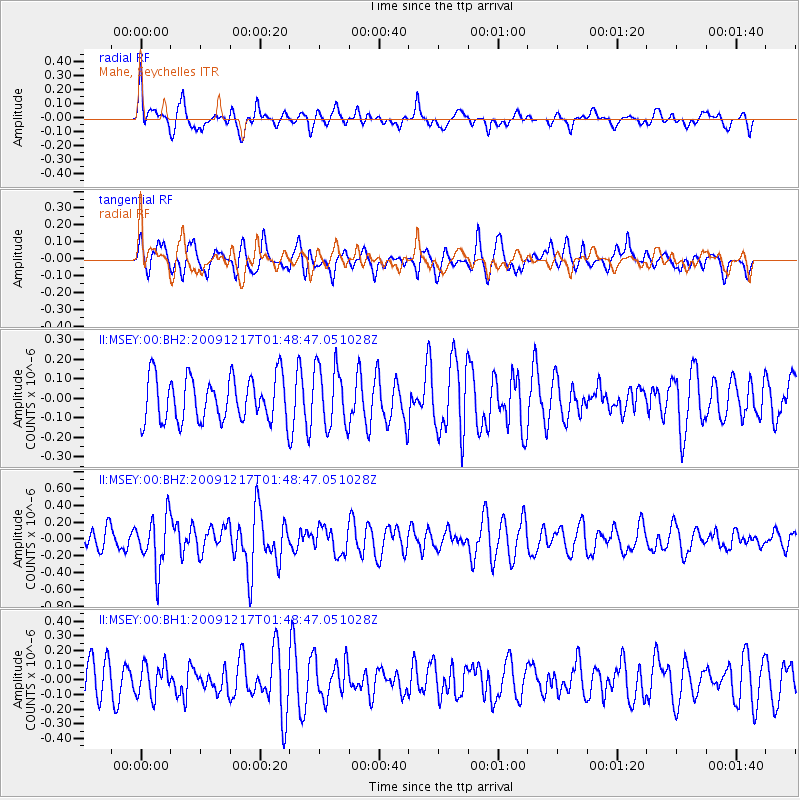
Signal To Noise
| Channel | StoN | STA | LTA |
| II:MSEY:00:BHZ:20091217T01:48:47.051028Z | 2.0877683 | 3.0574932E-7 | 1.4644792E-7 |
| II:MSEY:00:BH1:20091217T01:48:47.051028Z | 0.7733348 | 1.0807211E-7 | 1.3974815E-7 |
| II:MSEY:00:BH2:20091217T01:48:47.051028Z | 1.3808199 | 1.5691377E-7 | 1.1363812E-7 |
| Arrivals |
| Ps | |
| PpPs | |
| PsPs/PpSs | |


