You are here: Home > Network List > US - United States National Seismic Network Stations List
> Station KSU1 Kansas State University--Konza Prairie, Kansas, USA > Earthquake Result Viewer
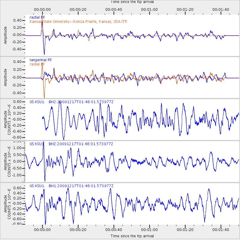
KSU1 Kansas State University--Konza Prairie, Kansas, USA - Earthquake Result Viewer
*The percent match for this event was below the threshold and hence no stack was calculated.
| Earthquake location: |
West Of Gibraltar |
| Earthquake latitude/longitude: |
36.5/-9.9 |
| Earthquake time(UTC): |
2009/12/17 (351) 01:37:48 GMT |
| Earthquake Depth: |
20 km |
| Earthquake Magnitude: |
5.6 MW, 5.5 MW, 5.7 MB |
| Earthquake Catalog/Contributor: |
NEIC PDE/NEIC PDE-M |
|
| Network: |
US United States National Seismic Network |
| Station: |
KSU1 Kansas State University--Konza Prairie, Kansas, USA |
| Lat/Lon: |
39.10 N/96.61 W |
| Elevation: |
347 m |
|
| Distance: |
65.9 deg |
| Az: |
301.709 deg |
| Baz: |
61.81 deg |
| Ray Param: |
$rayparam |
*The percent match for this event was below the threshold and hence was not used in the summary stack. |
|
| Radial Match: |
70.419266 % |
| Radial Bump: |
400 |
| Transverse Match: |
49.505337 % |
| Transverse Bump: |
400 |
| SOD ConfigId: |
617450 |
| Insert Time: |
2013-09-30 20:31:00.629 +0000 |
| GWidth: |
2.5 |
| Max Bumps: |
400 |
| Tol: |
0.001 |
|
Signal To Noise
| Channel | StoN | STA | LTA |
| US:KSU1: :BHZ:20091217T01:48:01.573977Z | 2.5699644 | 5.945291E-7 | 2.313375E-7 |
| US:KSU1: :BH1:20091217T01:48:01.573977Z | 1.5688149 | 3.4551886E-7 | 2.2024196E-7 |
| US:KSU1: :BH2:20091217T01:48:01.573977Z | 1.0595509 | 3.0550643E-7 | 2.8833577E-7 |
| Arrivals |
| Ps | |
| PpPs | |
| PsPs/PpSs | |


