You are here: Home > Network List > IU - Global Seismograph Network (GSN - IRIS/USGS) Stations List
> Station TEIG Tepich, Yucatan, Mexico > Earthquake Result Viewer
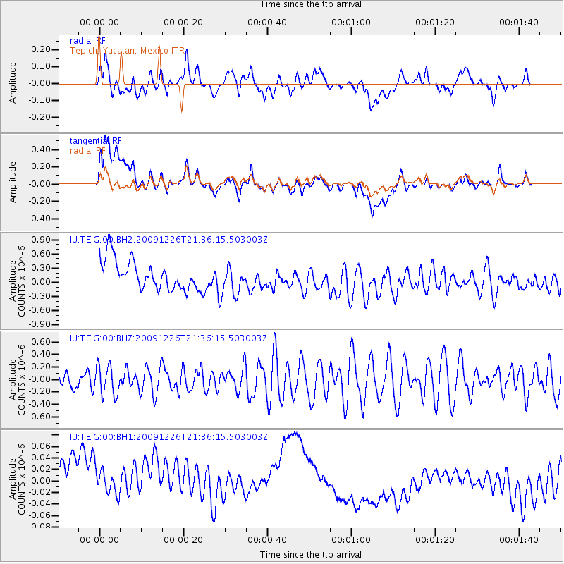
TEIG Tepich, Yucatan, Mexico - Earthquake Result Viewer
*The percent match for this event was below the threshold and hence no stack was calculated.
| Earthquake location: |
Fiji Islands Region |
| Earthquake latitude/longitude: |
-17.3/-176.9 |
| Earthquake time(UTC): |
2009/12/26 (360) 21:23:27 GMT |
| Earthquake Depth: |
17 km |
| Earthquake Magnitude: |
5.6 MW, 5.5 MW |
| Earthquake Catalog/Contributor: |
NEIC PDE/NEIC PDE-M |
|
| Network: |
IU Global Seismograph Network (GSN - IRIS/USGS) |
| Station: |
TEIG Tepich, Yucatan, Mexico |
| Lat/Lon: |
20.23 N/88.28 W |
| Elevation: |
40 m |
|
| Distance: |
94.6 deg |
| Az: |
70.373 deg |
| Baz: |
253.374 deg |
| Ray Param: |
$rayparam |
*The percent match for this event was below the threshold and hence was not used in the summary stack. |
|
| Radial Match: |
27.793146 % |
| Radial Bump: |
400 |
| Transverse Match: |
23.140545 % |
| Transverse Bump: |
400 |
| SOD ConfigId: |
617450 |
| Insert Time: |
2013-09-30 20:59:15.817 +0000 |
| GWidth: |
2.5 |
| Max Bumps: |
400 |
| Tol: |
0.001 |
|
Signal To Noise
| Channel | StoN | STA | LTA |
| IU:TEIG:00:BHZ:20091226T21:36:15.503003Z | 1.0777482 | 2.3679375E-7 | 2.1971158E-7 |
| IU:TEIG:00:BH1:20091226T21:36:15.503003Z | 0.6387611 | 8.720897E-8 | 1.365283E-7 |
| IU:TEIG:00:BH2:20091226T21:36:15.503003Z | 0.9733804 | 3.0287003E-7 | 3.111528E-7 |
| Arrivals |
| Ps | |
| PpPs | |
| PsPs/PpSs | |


