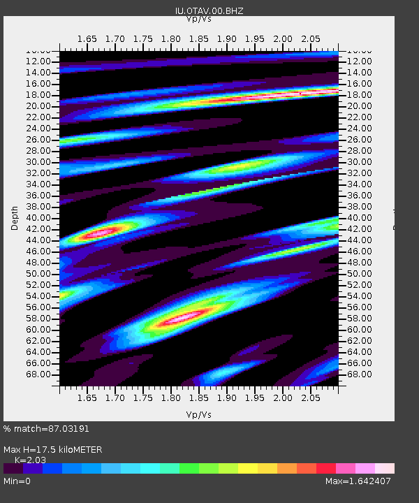
OTAV Otavalo, Ecuador - Earthquake Result Viewer
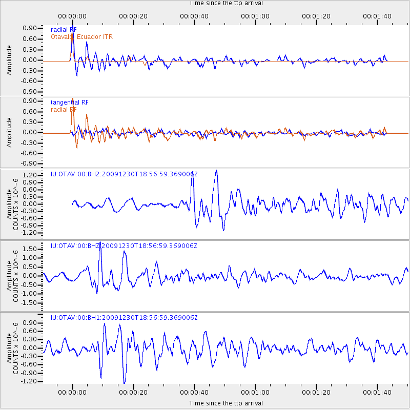
Earthquake location: Calif.-Baja Calif. Border Region
Earthquake latitude/longitude: 32.4/-115.2
Earthquake time(UTC): 2009/12/30 (364) 18:48:57 GMT
Earthquake Depth: 9.0 km
Earthquake Magnitude: 5.9 MW, 5.7 MB, 5.7 MS, 5.8 MW
Earthquake Catalog/Contributor: NEIC PDE/NEIC PDE-M
Network: IU Global Seismograph Network (GSN - IRIS/USGS)
Station: OTAV Otavalo, Ecuador
Lat/Lon: 0.24 N/78.45 W
Elevation: 3510 m
Distance: 47.2 deg
Az: 125.373 deg
Baz: 316.409 deg
Ray Param: 0.07018294
Estimated Moho Depth: 17.5 km
Estimated Crust Vp/Vs: 2.03
Assumed Crust Vp: 6.472 km/s
Estimated Crust Vs: 3.188 km/s
Estimated Crust Poisson's Ratio: 0.34
Radial Match: 87.03191 %
Radial Bump: 400
Transverse Match: 63.8525 %
Transverse Bump: 400
SOD ConfigId: 617450
Insert Time: 2013-09-30 21:08:29.769 +0000
GWidth: 2.5
Max Bumps: 400
Tol: 0.001

Signal To Noise

ChannelStoNSTALTA
IU:OTAV:00:BHZ:20091230T18:56:59.369006Z2.4129972.6061397E-71.0800427E-7
IU:OTAV:00:BH1:20091230T18:56:59.369006Z1.02355661.1274216E-71.1014746E-7
IU:OTAV:00:BH2:20091230T18:56:59.369006Z0.384146875.7002058E-81.483861E-7
Arrivals
Ps2.9 SECOND
PpPs7.8 SECOND
PsPs/PpSs11 SECOND