You are here: Home > Network List > II - Global Seismograph Network (GSN - IRIS/IDA) Stations List
> Station KURK Kurchatov, Kazakhstan > Earthquake Result Viewer
KURK Kurchatov, Kazakhstan - Earthquake Result Viewer
| Earthquake location: |
South Of Mariana Islands |
| Earthquake latitude/longitude: |
12.4/141.9 |
| Earthquake time(UTC): |
2010/01/02 (002) 08:45:33 GMT |
| Earthquake Depth: |
8.0 km |
| Earthquake Magnitude: |
6.0 MW, 5.7 MB, 5.9 MS, 6.1 MW |
| Earthquake Catalog/Contributor: |
NEIC PDE/NEIC PDE-M |
|
| Network: |
II Global Seismograph Network (GSN - IRIS/IDA) |
| Station: |
KURK Kurchatov, Kazakhstan |
| Lat/Lon: |
50.72 N/78.62 E |
| Elevation: |
184 m |
|
| Distance: |
63.7 deg |
| Az: |
320.66 deg |
| Baz: |
103.065 deg |
| Ray Param: |
0.05944067 |
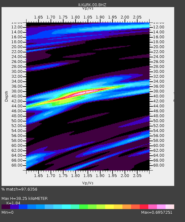
| Estimated Moho Depth: |
38.25 km |
| Estimated Crust Vp/Vs: |
1.84 |
| Assumed Crust Vp: |
6.552 km/s |
| Estimated Crust Vs: |
3.561 km/s |
| Estimated Crust Poisson's Ratio: |
0.29 |
|
| Radial Match: |
97.6356 % |
| Radial Bump: |
363 |
| Transverse Match: |
86.66536 % |
| Transverse Bump: |
400 |
| SOD ConfigId: |
617450 |
| Insert Time: |
2013-09-30 21:15:29.362 +0000 |
| GWidth: |
2.5 |
| Max Bumps: |
400 |
| Tol: |
0.001 |
|
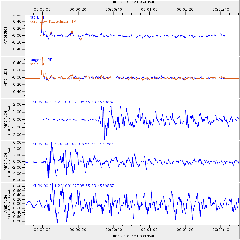
Signal To Noise
| Channel | StoN | STA | LTA |
| II:KURK:00:BHZ:20100102T08:55:33.457988Z | 16.592093 | 1.9443394E-6 | 1.171847E-7 |
| II:KURK:00:BH1:20100102T08:55:33.457988Z | 2.4077048 | 1.8434754E-7 | 7.656567E-8 |
| II:KURK:00:BH2:20100102T08:55:33.457988Z | 8.872388 | 7.4005453E-7 | 8.3410974E-8 |
| Arrivals |
| Ps | 5.1 SECOND |
| PpPs | 16 SECOND |
| PsPs/PpSs | 21 SECOND |


