You are here: Home > Network List > IU - Global Seismograph Network (GSN - IRIS/USGS) Stations List
> Station RSSD Black Hills, South Dakota, USA > Earthquake Result Viewer
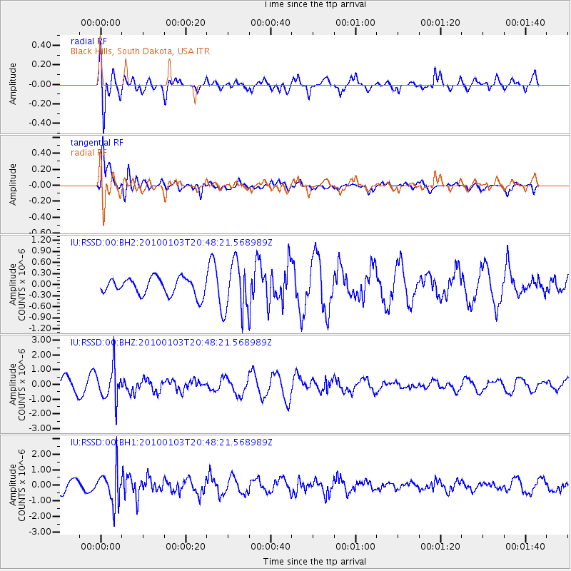
RSSD Black Hills, South Dakota, USA - Earthquake Result Viewer
*The percent match for this event was below the threshold and hence no stack was calculated.
| Earthquake location: |
Central Peru |
| Earthquake latitude/longitude: |
-8.8/-77.7 |
| Earthquake time(UTC): |
2010/01/03 (003) 20:39:12 GMT |
| Earthquake Depth: |
117 km |
| Earthquake Magnitude: |
5.7 MW, 5.7 MW, 5.9 MB |
| Earthquake Catalog/Contributor: |
NEIC PDE/NEIC PDE-M |
|
| Network: |
IU Global Seismograph Network (GSN - IRIS/USGS) |
| Station: |
RSSD Black Hills, South Dakota, USA |
| Lat/Lon: |
44.12 N/104.04 W |
| Elevation: |
2090 m |
|
| Distance: |
57.8 deg |
| Az: |
337.836 deg |
| Baz: |
148.82 deg |
| Ray Param: |
$rayparam |
*The percent match for this event was below the threshold and hence was not used in the summary stack. |
|
| Radial Match: |
53.82577 % |
| Radial Bump: |
400 |
| Transverse Match: |
77.929276 % |
| Transverse Bump: |
400 |
| SOD ConfigId: |
617450 |
| Insert Time: |
2013-09-30 21:19:07.539 +0000 |
| GWidth: |
2.5 |
| Max Bumps: |
400 |
| Tol: |
0.001 |
|
Signal To Noise
| Channel | StoN | STA | LTA |
| IU:RSSD:00:BHZ:20100103T20:48:21.568989Z | 2.3607273 | 1.1174843E-6 | 4.7336445E-7 |
| IU:RSSD:00:BH1:20100103T20:48:21.568989Z | 2.3679624 | 1.0814495E-6 | 4.5670043E-7 |
| IU:RSSD:00:BH2:20100103T20:48:21.568989Z | 2.9466412 | 6.7198414E-7 | 2.280509E-7 |
| Arrivals |
| Ps | |
| PpPs | |
| PsPs/PpSs | |


