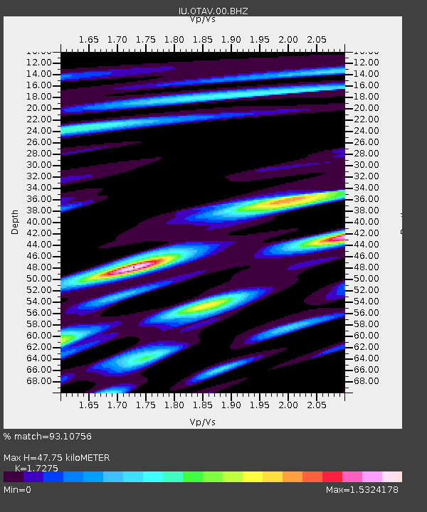
OTAV Otavalo, Ecuador - Earthquake Result Viewer
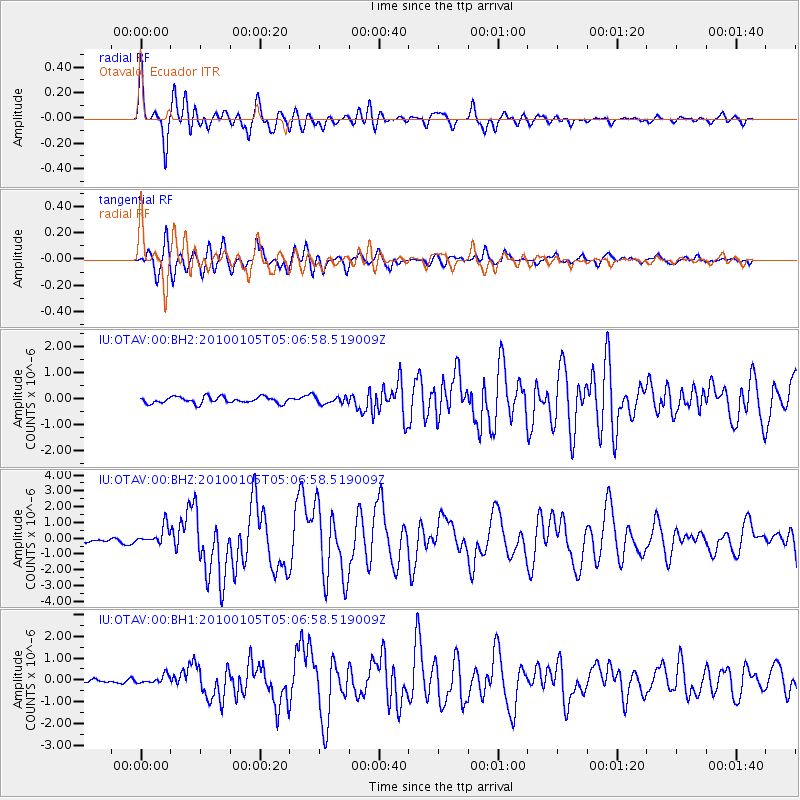
Earthquake location: East Of South Sandwich Islands
Earthquake latitude/longitude: -58.2/-14.7
Earthquake time(UTC): 2010/01/05 (005) 04:55:39 GMT
Earthquake Depth: 13 km
Earthquake Magnitude: 6.8 MW, 6.1 MB, 6.5 MS, 6.8 MW
Earthquake Catalog/Contributor: NEIC PDE/NEIC PDE-M
Network: IU Global Seismograph Network (GSN - IRIS/USGS)
Station: OTAV Otavalo, Ecuador
Lat/Lon: 0.24 N/78.45 W
Elevation: 3510 m
Distance: 76.7 deg
Az: 292.809 deg
Baz: 150.759 deg
Ray Param: 0.050843578
Estimated Moho Depth: 47.75 km
Estimated Crust Vp/Vs: 1.73
Assumed Crust Vp: 6.472 km/s
Estimated Crust Vs: 3.746 km/s
Estimated Crust Poisson's Ratio: 0.25
Radial Match: 93.10756 %
Radial Bump: 400
Transverse Match: 89.68465 %
Transverse Bump: 400
SOD ConfigId: 617450
Insert Time: 2013-09-30 21:27:21.835 +0000
GWidth: 2.5
Max Bumps: 400
Tol: 0.001

Signal To Noise

ChannelStoNSTALTA
IU:OTAV:00:BHZ:20100105T05:06:58.519009Z7.4708345.777205E-77.733013E-8
IU:OTAV:00:BH1:20100105T05:06:58.519009Z2.16447951.9455432E-78.9885035E-8
IU:OTAV:00:BH2:20100105T05:06:58.519009Z1.08631041.3488095E-71.2416427E-7
Arrivals
Ps5.5 SECOND
PpPs19 SECOND
PsPs/PpSs25 SECOND